Higashikagawa
東かがわ市 | |
|---|---|
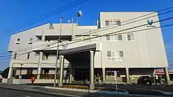
 Higashikagawa City Hall | |
 Flag  Emblem | |
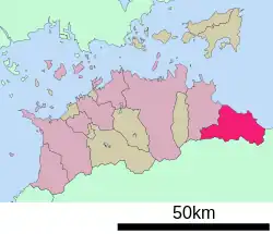
Location of Higashikagawa in Kagawa Prefecture | |
 | |
 Higashikagawa Location in Japan | |
| Coordinates: 34°15′N 134°22′E / 34.250°N 134.367°E | |
| Country | Japan |
| Region | Shikoku |
| Prefecture | Kagawa |
| Government | |
| • Mayor | Ichiro Uemura |
| Area | |
| • Total | 152.83 km2 (59.01 sq mi) |
| Population (September 30, 2022) | |
| • Total | 28,627 |
| • Density | 190/km2 (490/sq mi) |
| Time zone | UTC+09:00 (JST) |
| City hall address | 1847-1 Minato, Higashikagawa-shi, Kagawa-ken 769-2792 |
| Climate | Cfa |
| Website | Official website |


Higashikagawa (東かがわ市, Higashikagawa-shi) is a city located in Kagawa Prefecture, Japan. As of 30 September 2022, the city had an estimated population of 28,627 in 13689 households and a population density of and a population density of 970 persons per km².[2] The total area of the city is 152.83 square kilometres (59.01 sq mi).
Geography
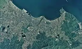
Higashikagawa is located in far eastern Kagawa Prefecture, on the island of Shikoku, facing the Seto Inland Sea to the north. The south borders Tokushima Prefecture through the Sanuki Mountains, which stretch from east to west. The city is located roughly halfway between Takamatsu City and Tokushima City.
Neighbouring municipalities
Kagawa Prefecture
Tokushima Prefecture
Climate
Higashikagawa has a humid subtropical climate (Köppen climate classification Cfa) with hot, humid summers, and cool winters. Some rain falls throughout the year, but the months from May to September have the heaviest rain. The average annual temperature in Higashikagawa is 15.9 °C (60.6 °F). The average annual rainfall is 1,343.6 mm (52.90 in) with September as the wettest month. The temperatures are highest on average in August, at around 27.2 °C (81.0 °F), and lowest in January, at around 5.5 °C (41.9 °F).[3] The highest temperature ever recorded in Higashikagawa was 37.0 °C (98.6 °F) on 13 August 1984; the coldest temperature ever recorded was −6.7 °C (19.9 °F) on 7 February 2018.[4]
| Climate data for Hiketa, Higashikagawa (1991−2020 normals, extremes 1978−present) | |||||||||||||
|---|---|---|---|---|---|---|---|---|---|---|---|---|---|
| Month | Jan | Feb | Mar | Apr | May | Jun | Jul | Aug | Sep | Oct | Nov | Dec | Year |
| Record high °C (°F) | 18.4 (65.1) |
24.2 (75.6) |
25.7 (78.3) |
30.9 (87.6) |
31.3 (88.3) |
35.1 (95.2) |
36.9 (98.4) |
37.0 (98.6) |
36.8 (98.2) |
31.5 (88.7) |
26.1 (79.0) |
23.0 (73.4) |
37.0 (98.6) |
| Mean daily maximum °C (°F) | 9.2 (48.6) |
9.8 (49.6) |
13.1 (55.6) |
18.8 (65.8) |
23.7 (74.7) |
26.4 (79.5) |
30.4 (86.7) |
31.7 (89.1) |
27.8 (82.0) |
22.4 (72.3) |
17.0 (62.6) |
11.8 (53.2) |
20.2 (68.3) |
| Daily mean °C (°F) | 5.5 (41.9) |
5.7 (42.3) |
8.6 (47.5) |
13.7 (56.7) |
18.6 (65.5) |
22.2 (72.0) |
26.1 (79.0) |
27.2 (81.0) |
23.8 (74.8) |
18.5 (65.3) |
13.1 (55.6) |
7.9 (46.2) |
15.9 (60.7) |
| Mean daily minimum °C (°F) | 1.8 (35.2) |
1.8 (35.2) |
4.2 (39.6) |
8.9 (48.0) |
14.1 (57.4) |
18.7 (65.7) |
22.9 (73.2) |
23.8 (74.8) |
20.6 (69.1) |
15.1 (59.2) |
9.3 (48.7) |
4.3 (39.7) |
12.1 (53.8) |
| Record low °C (°F) | −5.3 (22.5) |
−6.7 (19.9) |
−4.5 (23.9) |
−0.8 (30.6) |
4.4 (39.9) |
10.1 (50.2) |
16.6 (61.9) |
17.2 (63.0) |
10.6 (51.1) |
4.3 (39.7) |
1.6 (34.9) |
−3.0 (26.6) |
−6.7 (19.9) |
| Average precipitation mm (inches) | 36.3 (1.43) |
44.1 (1.74) |
72.9 (2.87) |
78.6 (3.09) |
111.3 (4.38) |
159.3 (6.27) |
159.4 (6.28) |
168.6 (6.64) |
244.0 (9.61) |
149.0 (5.87) |
62.0 (2.44) |
46.2 (1.82) |
1,343.6 (52.90) |
| Average precipitation days (≥ 1.0 mm) | 6.6 | 6.8 | 9.8 | 9.6 | 8.8 | 11.3 | 10.1 | 8.6 | 10.5 | 8.9 | 6.9 | 6.6 | 104.5 |
| Mean monthly sunshine hours | 147.6 | 140.3 | 176.7 | 202.5 | 207.3 | 154.2 | 194.6 | 227.1 | 156.6 | 154.3 | 137.5 | 137.6 | 2,039.1 |
| Source: Japan Meteorological Agency[4][3] | |||||||||||||
Demographics
Per Japanese census data, the population of Higashikagawa in 2020 is 28,279 people.[5] Higashikagawa has been conducting censuses since 1920.
| Year | Pop. | ±% |
|---|---|---|
| 1920 | 32,161 | — |
| 1925 | 32,137 | −0.1% |
| 1930 | 33,909 | +5.5% |
| 1935 | 34,830 | +2.7% |
| 1940 | 34,326 | −1.4% |
| 1945 | 46,248 | +34.7% |
| 1950 | 45,831 | −0.9% |
| 1955 | 44,662 | −2.6% |
| 1960 | 44,428 | −0.5% |
| 1965 | 44,577 | +0.3% |
| 1970 | 42,572 | −4.5% |
| 1975 | 43,049 | +1.1% |
| 1980 | 43,110 | +0.1% |
| 1985 | 42,446 | −1.5% |
| 1990 | 40,875 | −3.7% |
| 1995 | 39,226 | −4.0% |
| 2000 | 37,760 | −3.7% |
| 2005 | 35,929 | −4.8% |
| 2010 | 33,646 | −6.4% |
| 2015 | 31,031 | −7.8% |
| 2020 | 28,279 | −8.9% |
| Higashikagawa population statistics[5] | ||
History
The area of Higashikagawa was part of ancient Sanuki Province. From the Heian period the Hiketa port prospered as a good natural harbor and a gateway to Shikoku from the Kinai region. From the Sengoku period, Hiketa Castle was a stronghold of the Ikoma clan and a castle town developed around the fortifications. Even today, many of the intricate alleyways and old buildings from the Edo and Meiji periods still exist, preserving the atmosphere of a pre-modern fishing town. During the Edo Period, this area was part of the holdings of Takamatsu Domain. Following the Meiji restoration, the area was organized into villages within Ōchi District, Kagawa with the creation of the modern municipalities system on February 15,1890. Hiketa was elevated to town status on October 1, 1909. The city of Higashikagawa was the result of a merger on April 1, 2003 between Hiketa and the towns of Ōchi and Shirotori, both from Ōkawa District (which was dissolved as a result of the merger).[6]
Government
Higashikagawa has a mayor-council form of government with a directly elected mayor and a unicameral city council of 18 members. Higashikagawa contributes two members to the Kagawa Prefectural Assembly. In terms of national politics, the city is within the Kagawa 2nd district of the lower house of the Diet of Japan.
Economy
Higashikagawa has a mixed economy centered on light manufacturing, commercial fishing and agriculture.[7] Traditionally, the city was noted for its production of gloves, claiming a 90% market share;[8] however, due to labor costs, much of the market has been lost to China and southeast Asia. Another prominent industry is the manufacturing of bearings. JTEKT (formerly Koyo Seiko), one of the major companies of the Toyota Group, produces 25% of the global market share of tapered roller bearings. The former town of Hiketa is a center for producing wasanbon, a fine-grained sugar traditional to the region.[9] In terms of fishing, Yellowtail was first successfully farmed here.[10]
Education
Higashikagawa has two public elementary schools and two public middle schools operated by the city government, and one public high schools operated by the Kagawa Prefectural Board of Education.
Transportation
Railways
- Sanuki-Aioi - Hiketa - Sanuki-Shirotori - Sambommatsu - Nibu
Highways
Local attractions
- Hiketa Castle, where the Battle of Hiketa was fought in 1583, are in the eastern part of the city.[11][12]
Noted people from Higashikagawa
- Shizuko Kasagi, singer and actress
- Kono Yasui, biologist, first woman Phd in Japan
- Shōzō Fujii, Olympic gold medalist judoka
- Yukiharu Yoshitaka, Olympic gold medalist judoka
References
- ↑ "Areas of Prefectures, Cities, etc. (in Japanese)". Geospatial Information Authority of Japan. January 1, 2021. p. 64. Retrieved 30 March 2021.
- ↑ "Higashikagawa city official statistics" (in Japanese). Japan.
- 1 2 気象庁 / 平年値(年・月ごとの値). JMA. Retrieved April 24, 2022.
- 1 2 観測史上1~10位の値(年間を通じての値). JMA. Retrieved April 24, 2022.
- 1 2 Higashikagawa population statistics
- ↑ "Overview of Higashikagawa City (in Japanese)". Higashikagawa City. Retrieved 30 March 2021.
- ↑ "導入促進基本計画 [Basic Plan for Industry Promotion] (in Japanese)". Higashikagawa City. 2018. Retrieved 30 March 2021.
- ↑ "Gloves (in Japanese)". Love Sanuki. Kagawa Prefectural Products Promotion Organization. Retrieved March 30, 2021.
- ↑ "Wasanbon". Love Sanuki. Kagawa Prefectural Products Promotion Organization.
- 1 2 "Basic Information on Higashikagawa (in Japanese)" (PDF). Higashikagawa City. 2020. Retrieved March 30, 2021.
- ↑ "Hiketa Castle (in Japanese)" (PDF). Higashikagawa City. Board of Education, Higashikagawa City. 2018. Retrieved 2 April 2021.
- ↑ "Site of Hiketa Castle (in Japanese)". Cultural Properties Database. Agency for Cultural Affairs.
- ↑ "Toramaru Puppet Land (in Japanese)". Retrieved 30 March 2021.
External links
 Media related to Higashikagawa, Kagawa at Wikimedia Commons
- Higashikagawa City official website (in Japanese)