Sikka Regency
Kabupaten Sikka | |
|---|---|
 Beach of Maumere | |
 Coat of arms | |
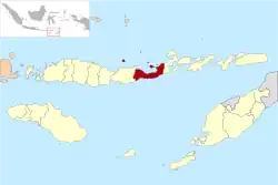 Location within East Nusa Tenggara | |
 Sikka Regency  Sikka Regency Sikka Regency (Lesser Sunda Islands)  Sikka Regency Sikka Regency (Indonesia) | |
| Coordinates: 8°29′18″S 122°58′26″E / 8.48833°S 122.974°E | |
| Country | |
| Region | Lesser Sunda Islands |
| Province | |
| Capital | Maumere |
| Government | |
| • Regent | Ansar Rera |
| • Vice Regent | Paolus Nong Susar |
| Area | |
| • Total | 668.69 sq mi (1,731.91 km2) |
| Population (mid 2022 estimate) | |
| • Total | 326,999 |
| • Density | 490/sq mi (190/km2) |
| [1] | |
| Area code | (+62) 382 |
| Website | sikkakab |
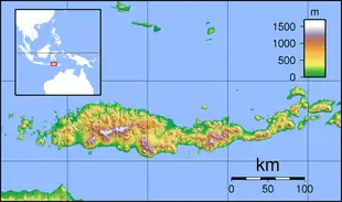
Sikka is a regency within East Nusa Tenggara province, Indonesia, on the island of Flores.[2] It is bordered to the west by Ende Regency and to the east by East Flores Regency. It covers an area of 1,731.91 km2 and had a population of 300,301 at the 2010 census[3] and 321,953 at the 2020 Census;[4] the official estimate as at mid 2022 was 326,999.[1] The capital is the town of Maumere, which comprises the districts of Alok Barat, Alok and Alok Timur (although the last two also include a number of notable islands to the north of Flores).
Politics
Paulus Moa was Regent of Sikka for a few years between 2002 and 2006.
The regency is divided into twenty-one districts (kecamatan), tabulated below with their areas and their populations at the 2010 census[3] and the 2020 census,[4] together with the official estimates as at mid 2022.[1] The table also includes the locations of the district administrative centres, the number of administrative villages in each district (totaling 147 rural desa and 13 urban kelurahan - the latter all in the three "Alok" districts which comprise Maumere town), and its post code.
| Kode Wilayah | Name of District (kecamatan) | Area in km2 | Pop'n census 2010 | Pop'n census 2020 | Pop'n estimate mid 2022 | Admin centre | No. of villages | Post codes |
|---|---|---|---|---|---|---|---|---|
| 53.07.01 | Paga | 82.85 | 15,598 | 16,399 | 16,580 | Paga | 8 | 86153 |
| 53.07.02 | Mego | 111.26 | 11,873 | 12,939 | 13,170 | Lekebai | 10 | 86113 |
| 53.07.17 | Tana Wawo | 79.78 | 8,695 | 8,926 | 8,980 | Wolofeo | 6 | 86154 |
| 53.07.03 | Lela | 31.33 | 11,645 | 11,596 | 11,610 | Lela | 9 | 86161 |
| 53.07.11 | Bola | 56.83 | 10,785 | 10,797 | 10,810 | Bola | 6 | 86171 |
| 53.07.20 | Doreng | 30.41 | 11,191 | 12,002 | 12,180 | Waihawa | 7 | 86170 |
| 53.07.21 | Mapitara | 81.02 | 6,304 | 6,672 | 6,750 | Hebing | 4 | 86172 |
| 53.07.08 | Talibura | 260.11 | 20,454 | 22,424 | 22,850 | Talibura | 12 | 86183 |
| 53.07.09 | Waigete | 217.65 | 22,181 | 24,931 | 25,530 | Waigete | 6 | 86184 |
| 53.07.13 | Waiblama | 144.36 | 7,042 | 8,074 | 8,300 | Tanarawa | 9 | 86185 |
| 53.07.10 | Kewapante | 24.14 | 13,453 | 14,775 | 15,060 | Kewapante | 8 | 86182 |
| 53.07.18 | Hewokloang | 17.58 | 8,243 | 8,998 | 9,160 | Baowunut | 7 | 86181 |
| 53.07.19 | Kangae | 38.43 | 16,389 | 18,055 | 18,420 | Waippare | 9 | 86180 |
| 53.07.06 | Palu'e (a) | 41.00 | 9,553 | 9,497 | 9,510 | Uwa | 8 | 86110 |
| 53.07.16 | Koting | 23.56 | 6,360 | 6,526 | 6,570 | Koting D | 6 | 86116 |
| 53.07.07 | Nelle | 14.65 | 5,792 | 6,147 | 6,230 | Nelle Urung | 5 | 86119 |
| 53.07.04 | Nita | 141.07 | 21,223 | 22,748 | 23,080 | Nita | 12 | 86151 |
| 53.07.12 | Magepanda | 166.15 | 11,508 | 12,727 | 12,990 | Magepanda | 5 | 86152 |
| 53.07.05 | Alok (b) (Central Alok) | 14.64 | 33,064 | 32,629 | 32,670 | Kota Uneng | 7 (c) | 86112 -86118 |
| 53.07.14 | Alok Barat (West Alok) | 62.75 | 16,808 | 22,294 | 23,580 | Wailiti | 4 (d) | 86114 -86115 |
| 53.07.15 | Alok Timur (e) (East Alok) | 92.34 | 32,167 | 32,797 | 32,960 | Waioti | 10 (f) | 86111 -86115 |
| Totals | 1,731.91 | 300,328 | 321,953 | 326,999 | Maumere | 160 |
Note: (a) Palu'e is an island district, situated off the north coast of Flores. (b) includes the offshore islands of Pulau Pemana Besar and Pulau Pemana Kecil (with a combined population of 4,268 in mid 2021) and, further north, Pulau Sukun or Samparong (with a population of 1,532 in mid 2021). (c) comprises 4 kelurahan and 3 desa. (d) all kelurahan. (e) includes the offshore islands of Pulau Koja or Pulau Besar (with 2,960 inhabitants in mid 2021), Pulau Parumaan (with 1,816 inhabitants in mid 2021 - including Pulau Pangabatan, Pulau Mermaan and Pulau Damhila), and nearby Pulau Babi. (f) comprising 5 kelurahan and 5 desa.
See also
References
Regencies and cities of East Nusa Tenggara | ||
|---|---|---|
Capital: Kupang | ||
| Regencies |  | |
| Cities | ||