| Silver State North Solar Project | |
|---|---|
| Country | United States |
| Location | Clark County |
| Coordinates | 35°37′36″N 115°21′12″W / 35.62667°N 115.35333°W |
| Status | Operational |
| Commission date | May 7, 2012 |
| Owner(s) | First Solar |
| Solar farm | |
| Type | Flat-panel PV fixed tilt |
| Site area | 600 acres |
| Power generation | |
| Nameplate capacity | 60 MWp, 50 MWAC |
| Capacity factor | 27.0% (average 2013-2019) |
| Annual net output | 118 GW·h, 197 MW·h/acre |

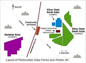
Layout of the project near Primm, NV
Silver State North Solar Project is a 60 MWp (50 MWAC) photovoltaic power station near Primm, Nevada.[1]
Electricity production
| Year | Jan | Feb | Mar | Apr | May | Jun | Jul | Aug | Sep | Oct | Nov | Dec | Total |
|---|---|---|---|---|---|---|---|---|---|---|---|---|---|
| 2012 | 7,098 | 12,992 | 12,472 | 10,838 | 8,975 | 9,177 | 10,877 | 8,345 | 6,968 | 87,742 | |||
| 2013 | 8,305 | 8,986 | 10,653 | 11,677 | 12,326 | 12,064 | 10,338 | 10,750 | 10,247 | 10,808 | 7,992 | 8,102 | 122,248 |
| 2014 | 8,318 | 8,463 | 11,022 | 11,075 | 12,119 | 11,952 | 10,525 | 10,906 | 10,874 | 10,720 | 8,893 | 4,925 | 119,792 |
| 2015 | 7,504 | 9,171 | 10,788 | 11,778 | 11,041 | 11,441 | 10,804 | 11,125 | 10,543 | 9,340 | 8,966 | 7,325 | 119,826 |
| 2016 | 6,454 | 9,727 | 10,252 | 10,212 | 11,825 | 11,440 | 11,766 | 11,036 | 10,636 | 9,560 | 8,253 | 6,385 | 117,546 |
| 2017 | 4,846 | 5,386 | 9,296 | 10,235 | 11,455 | 12,081 | 11,687 | 12,843 | 12,105 | 11,777 | 7,671 | 7,225 | 116,607 |
| 2018 | 5,601 | 7,183 | 9,200 | 11,486 | 12,147 | 14,225 | 12,117 | 12,253 | 11,786 | 9,240 | 7,223 | 5,592 | 118,054 |
| 2019 | 5,993 | 6,558 | 9,072 | 10,733 | 11,376 | 12,529 | 12,652 | 12,319 | 10,539 | 10,224 | 6,977 | 4,712 | 113,676 |
| Average Annual Production (years 2013–2019) ---> | 118,250 | ||||||||||||
See also
References
- ↑ First Solar Silver State North Solar Project Archived 2013-03-13 at the Wayback Machine
- ↑ "Silver State Solar Power North, Monthly". Electricity Data Browser. Energy Information Administration. Retrieved November 2, 2019.
External links
This article is issued from Wikipedia. The text is licensed under Creative Commons - Attribution - Sharealike. Additional terms may apply for the media files.