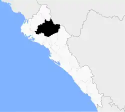
Sinaloa Municipality
Municipio de Sinaloa | |
|---|---|
 Seal | |
 Location of the municipality in Sinaloa | |
| Coordinates: 25°49′N 108°13′W / 25.817°N 108.217°W | |
| Country | |
| State | |
| Seat | Sinaloa de Leyva |
| No. of Sindicaturas | 9 |
| Foundation | 1915 |
| Government | |
| • Municipal president | Saúl Rubio Valenzuela |
| Area | |
| • Total | 6,186.5 km2 (2,388.6 sq mi) |
| Population (2010) | |
| • Total | 88,282[1] |
| Time zone | UTC-7 (Mountain Standard Time) |
| • Summer (DST) | UTC-6 (Mountain Daylight Time) |
| Website | Official website |
Municipality of Sinaloa is a municipality in the Mexican state of Sinaloa in northwestern Mexico.[2] Its seat is Sinaloa de Leyva.
Political subdivision
Sinaloa Municipality is subdivided in 9 sindicaturas:
- Bacubirito
- Estación Naranjo
- Lázaro Cárdenas (Ejido Ruiz Cortines No. 1)
- Llano Grande
- Maquipo
- Ocoroni
- Palmar de los Sepúlveda
- San José de Gracia
- San José de las Delicias
Economy
Agriculture is one of the three main economical activities in this municipality, with cultivation of maize, beans, soy, wheat, sorghum, tomato and sesame representing the main preferences. Cattle farming is another of the three activities, with 6820 registered cattle farmers, as well as 52235 heads of cattle. In a much more reduced quantity, pigs are reared, as well as domestic birds. The industrial aspect of the economy consists of a furniture factory, as well as a hydroelectric plant belonging to CFE.
References
- ↑ "Main results by locality 2010". INEGI. 2010.
- ↑ "-". Enciclopedia de los Municipios de México. Instituto Nacional para el Federalismo y el Desarrollo Municipal. Retrieved 11 January 2010.
External links
![]() Media related to Sinaloa Municipality at Wikimedia Commons
Media related to Sinaloa Municipality at Wikimedia Commons
