South Carolina Highway 363 | ||||
|---|---|---|---|---|
 | ||||
| Route information | ||||
| Maintained by SCDOT | ||||
| Length | 13.270 mi[1] (21.356 km) | |||
| Existed | 1940–present | |||
| Major junctions | ||||
| West end | ||||
| East end | ||||
| Location | ||||
| Country | United States | |||
| State | South Carolina | |||
| Counties | Hampton | |||
| Highway system | ||||
| ||||

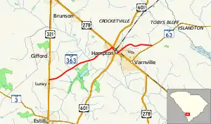
South Carolina Highway 363 (SC 363) is a 13.270-mile-long (21.356 km) state highway in the U.S. state of South Carolina. The highway is designated on an east–west direction, from U.S. Route 321 (US 321) in Luray to SC 63 just outside Varnville.
Route description
History
Major intersections
The entire route is in Hampton County.
| Location | mi[1] | km | Destinations | Notes | |
|---|---|---|---|---|---|
| | 0.000 | 0.000 | Western terminus | ||
| Hampton | 8.060 | 12.971 | Western end of US 278 concurrency | ||
| 8.220 | 13.229 | Western end of US 601 concurrency | |||
| 8.780 | 14.130 | Eastern end of US 601 concurrency | |||
| 8.970 | 14.436 | Eastern end of US 278 concurrency | |||
| | 13.270 | 21.356 | Eastern terminus | ||
1.000 mi = 1.609 km; 1.000 km = 0.621 mi
| |||||
See also
References
- 1 2 "Highway Logmile Report". South Carolina Department of Transportation. Retrieved December 28, 2020.
External links
Template:Attached KML/South Carolina Highway 363
KML is from Wikidata
Wikimedia Commons has media related to South Carolina Highway 363.
This article is issued from Wikipedia. The text is licensed under Creative Commons - Attribution - Sharealike. Additional terms may apply for the media files.