Sparneck | |
|---|---|
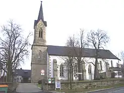 Church of Saint Vitus | |
 Coat of arms | |
Location of Sparneck within Hof district  | |
 Sparneck 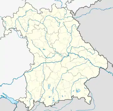 Sparneck | |
| Coordinates: 50°10′N 11°49′E / 50.167°N 11.817°E | |
| Country | Germany |
| State | Bavaria |
| Admin. region | Oberfranken |
| District | Hof |
| Municipal assoc. | Sparneck |
| Subdivisions | 9 Ortsteile |
| Government | |
| • Mayor (2020–26) | Daniel Schreiner[1] |
| Area | |
| • Total | 16.36 km2 (6.32 sq mi) |
| Elevation | 560 m (1,840 ft) |
| Population (2022-12-31)[2] | |
| • Total | 1,573 |
| • Density | 96/km2 (250/sq mi) |
| Time zone | UTC+01:00 (CET) |
| • Summer (DST) | UTC+02:00 (CEST) |
| Postal codes | 95234 |
| Dialling codes | 09251 |
| Vehicle registration | HO |
| Website | www.sparneck.de |
Sparneck is a municipality in Upper Franconia in the district of Hof in Bavaria in Germany.
Location
The market town of Sparneck lies at an average height of 560 m above sea level (NN) in the Pfarrbach valley, which forms the larger part of the area. The Saxon Saale river flows through this valley in a northerly direction. Towards the east the 877 metre high Waldstein ridge rises, the source of the Saale is on its slopes. It forms the natural boundary with the neighbouring district of Wunsiedel.
History
Sparneck is first mentioned 1223 with a person from Sparneck family.
References
- ↑ Liste der ersten Bürgermeister/Oberbürgermeister in kreisangehörigen Gemeinden, Bayerisches Landesamt für Statistik, 15 July 2021.
- ↑ Genesis Online-Datenbank des Bayerischen Landesamtes für Statistik Tabelle 12411-003r Fortschreibung des Bevölkerungsstandes: Gemeinden, Stichtag (Einwohnerzahlen auf Grundlage des Zensus 2011)
Wikimedia Commons has media related to Sparneck.
Towns and municipalities in Hof (district) | ||
|---|---|---|
| Coat of Arms of Hof district | |
This article is issued from Wikipedia. The text is licensed under Creative Commons - Attribution - Sharealike. Additional terms may apply for the media files.