Spojil | |
|---|---|
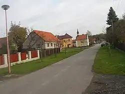 Main street towards northeast | |
 Flag  Coat of arms | |
 Spojil Location in the Czech Republic | |
| Coordinates: 50°2′32″N 15°49′19″E / 50.04222°N 15.82194°E | |
| Country | |
| Region | Pardubice |
| District | Pardubice |
| Founded | 1785 |
| Area | |
| • Total | 1.75 km2 (0.68 sq mi) |
| Elevation | 221 m (725 ft) |
| Population (2023-01-01)[1] | |
| • Total | 533 |
| • Density | 300/km2 (790/sq mi) |
| Time zone | UTC+1 (CET) |
| • Summer (DST) | UTC+2 (CEST) |
| Postal code | 530 02 |
| Website | www |
Spojil is a municipality and village in Pardubice District in the Pardubice Region of the Czech Republic. It has about 500 inhabitants.
Geography
Spojil forms an enclave in the territory of the city of Pardubice. It lies in a flat landscape of the East Elbe Table lowland.
History
Spojil is quite young among Czech villages as it was founded in 1785 at the site of two former fish ponds named Spojil and Strejček.[2]
The village was part of Pardubice from 1961 until 1991.[3]
Sights
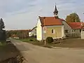
There is only one minor sight, the Chapel of the Assumption of the Virgin Mary built in 1868.[4]
Gallery
 Main street towards southwest
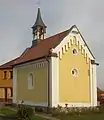 Chapel of the Assumption of the Virgin Mary
References
- ↑ "Population of Municipalities – 1 January 2023". Czech Statistical Office. 2023-05-23.
- ↑ "Starší historie obce" (in Czech). Obec Spojil. Retrieved 2021-10-13.
- ↑ "Historický lexikon obcí České republiky 1869–2011" (in Czech). Czech Statistical Office. 2015-12-21. p. 526.
- ↑ "Kaplička" (in Czech). Obec Spojil. Retrieved 2021-10-13.
External links
Wikimedia Commons has media related to Spojil.
This article is issued from Wikipedia. The text is licensed under Creative Commons - Attribution - Sharealike. Additional terms may apply for the media files.