Spotswood | ||||||||||||||||||||||||||||||||||||||||||||||||||||||||||||||||||||||||
|---|---|---|---|---|---|---|---|---|---|---|---|---|---|---|---|---|---|---|---|---|---|---|---|---|---|---|---|---|---|---|---|---|---|---|---|---|---|---|---|---|---|---|---|---|---|---|---|---|---|---|---|---|---|---|---|---|---|---|---|---|---|---|---|---|---|---|---|---|---|---|---|---|
| PTV commuter rail station | ||||||||||||||||||||||||||||||||||||||||||||||||||||||||||||||||||||||||
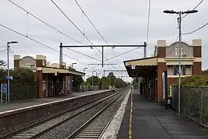
 Southbound view from Platform 1 in September 2022 | ||||||||||||||||||||||||||||||||||||||||||||||||||||||||||||||||||||||||
| General information | ||||||||||||||||||||||||||||||||||||||||||||||||||||||||||||||||||||||||
| Location | Hope Street, Spotswood, Victoria 3015 City of Hobsons Bay Australia | |||||||||||||||||||||||||||||||||||||||||||||||||||||||||||||||||||||||
| Coordinates | 37°49′50″S 144°53′09″E / 37.8306°S 144.8858°E | |||||||||||||||||||||||||||||||||||||||||||||||||||||||||||||||||||||||
| Owned by | VicTrack | |||||||||||||||||||||||||||||||||||||||||||||||||||||||||||||||||||||||
| Operated by | Metro Trains | |||||||||||||||||||||||||||||||||||||||||||||||||||||||||||||||||||||||
| Line(s) | ||||||||||||||||||||||||||||||||||||||||||||||||||||||||||||||||||||||||
| Distance | 9.22 kilometres from Southern Cross | |||||||||||||||||||||||||||||||||||||||||||||||||||||||||||||||||||||||
| Platforms | 2 side | |||||||||||||||||||||||||||||||||||||||||||||||||||||||||||||||||||||||
| Tracks | 2 | |||||||||||||||||||||||||||||||||||||||||||||||||||||||||||||||||||||||
| Construction | ||||||||||||||||||||||||||||||||||||||||||||||||||||||||||||||||||||||||
| Structure type | Ground | |||||||||||||||||||||||||||||||||||||||||||||||||||||||||||||||||||||||
| Parking | 15 | |||||||||||||||||||||||||||||||||||||||||||||||||||||||||||||||||||||||
| Bicycle facilities | Yes | |||||||||||||||||||||||||||||||||||||||||||||||||||||||||||||||||||||||
| Accessible | Yes—step free access | |||||||||||||||||||||||||||||||||||||||||||||||||||||||||||||||||||||||
| Other information | ||||||||||||||||||||||||||||||||||||||||||||||||||||||||||||||||||||||||
| Status | Operational, unstaffed | |||||||||||||||||||||||||||||||||||||||||||||||||||||||||||||||||||||||
| Station code | SPT | |||||||||||||||||||||||||||||||||||||||||||||||||||||||||||||||||||||||
| Fare zone | Myki Zone 1 | |||||||||||||||||||||||||||||||||||||||||||||||||||||||||||||||||||||||
| Website | Public Transport Victoria | |||||||||||||||||||||||||||||||||||||||||||||||||||||||||||||||||||||||
| History | ||||||||||||||||||||||||||||||||||||||||||||||||||||||||||||||||||||||||
| Opened | 1 December 1878 | |||||||||||||||||||||||||||||||||||||||||||||||||||||||||||||||||||||||
| Electrified | August 1920 (1500 V DC overhead) | |||||||||||||||||||||||||||||||||||||||||||||||||||||||||||||||||||||||
| Previous names | Edom (1878-1881) Bayswater (1881) Spottiswoode (1881-1905) | |||||||||||||||||||||||||||||||||||||||||||||||||||||||||||||||||||||||
| Passengers | ||||||||||||||||||||||||||||||||||||||||||||||||||||||||||||||||||||||||
| 2005–2006 | 183,269[1] | |||||||||||||||||||||||||||||||||||||||||||||||||||||||||||||||||||||||
| 2006–2007 | 200,275[1] | |||||||||||||||||||||||||||||||||||||||||||||||||||||||||||||||||||||||
| 2007–2008 | 220,175[1] | |||||||||||||||||||||||||||||||||||||||||||||||||||||||||||||||||||||||
| 2008–2009 | 255,816[2] | |||||||||||||||||||||||||||||||||||||||||||||||||||||||||||||||||||||||
| 2009–2010 | 267,640[2] | |||||||||||||||||||||||||||||||||||||||||||||||||||||||||||||||||||||||
| 2010–2011 | 257,659[2] | |||||||||||||||||||||||||||||||||||||||||||||||||||||||||||||||||||||||
| 2011–2012 | 254,230[2] | |||||||||||||||||||||||||||||||||||||||||||||||||||||||||||||||||||||||
| 2012–2013 | Not measured[2] | |||||||||||||||||||||||||||||||||||||||||||||||||||||||||||||||||||||||
| 2013–2014 | 280,837[2] | |||||||||||||||||||||||||||||||||||||||||||||||||||||||||||||||||||||||
| 2014–2015 | 293,792[1] | |||||||||||||||||||||||||||||||||||||||||||||||||||||||||||||||||||||||
| 2015–2016 | 322,964[2] | |||||||||||||||||||||||||||||||||||||||||||||||||||||||||||||||||||||||
| 2016–2017 | 318,215[2] | |||||||||||||||||||||||||||||||||||||||||||||||||||||||||||||||||||||||
| 2017–2018 | 329,126[2] | |||||||||||||||||||||||||||||||||||||||||||||||||||||||||||||||||||||||
| 2018–2019 | 344,850[2] | |||||||||||||||||||||||||||||||||||||||||||||||||||||||||||||||||||||||
| 2019–2020 | 273,300[2] | |||||||||||||||||||||||||||||||||||||||||||||||||||||||||||||||||||||||
| 2020–2021 | 122,500[2] | |||||||||||||||||||||||||||||||||||||||||||||||||||||||||||||||||||||||
| 2021–2022 | 170,900[3] | |||||||||||||||||||||||||||||||||||||||||||||||||||||||||||||||||||||||
| Services | ||||||||||||||||||||||||||||||||||||||||||||||||||||||||||||||||||||||||
| ||||||||||||||||||||||||||||||||||||||||||||||||||||||||||||||||||||||||
| ||||||||||||||||||||||||||||||||||||||||||||||||||||||||||||||||||||||||
Spotswood railway station is located on the Werribee and Williamstown lines in Victoria, Australia. It serves the western Melbourne suburb of Spotswood, and opened on 1 December 1878 as Edom. It was renamed Bayswater on 1 September 1881, renamed Spottiswoode on 1 October of that year, and renamed Spotswood on 1 August 1905.[4][5]
History
Spotswood station opened on 1 December 1878[4] and, like the suburb itself, was named after John Stewart Spottiswoode, a local resident who purchased land in the area in 1841.[6]
Over the years, a number of sidings were provided to businesses in the area. In 1914, a branch line was opened at the down end of the station to the Newport Power Station, in addition to a number of other sidings serving oil terminals in the area. A siding at the up end of the station served the Australian Glass Manufacturers factory, and was used by sand trains from Koala Siding (near Nyora on the South Gippsland line). On 15 January 1998, the last sand train operated.[7]
In 1972, both platforms received extensions.[8] In 1988, a number of points and dwarf signals at the station were abolished.[4] In 1989, boom barriers replaced interlocked gates at the Hudson Road level crossing, located at the up end of the station.[5]
In 1994, a number of alterations occurred at the station, including the removal of a crossover at the down end, as well as the overhead wire for siding "K", the connections for siding "K" and the oil sidings, and a number of points and signals.[4]
A disused signal box is at the up end of Platform 1. It was decommissioned on 12 August 2001,[9] along with the removal of the crossover at the up end, a number of dwarf signals and a siding.[5] In 2007, the remains of some sidings that ran along public roads in the area were removed by Hobsons Bay Council.[5]
On 26 October 2022, the Level Crossing Removal Project announced that the level crossing will be grade separated by 2030, with the railway line likely to be rebuilt over the road, and will include a rebuilt station.[10][11]
Platforms and services
Spotswood has two side platforms. It is served by Werribee and Williamstown line trains.[12][13]
Platform 1:
- Werribee line all stations services to Flinders Street and Frankston
- Williamstown line all stations services to Flinders Street and Frankston
Platform 2:
- Werribee line all stations services to Laverton via Altona (weekdays only); all stations services to Werribee
- Williamstown line all stations services to Williamstown
Gallery
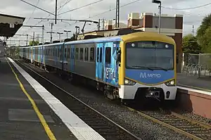
 Werribee bound Siemens train arriving into Platform 2 in April 2013
References
- 1 2 3 4 Estimated Annual Patronage by Network Segment Financial Year 2005-2006 to 2018-19 Archived 17 April 2022 at the Wayback Machine Department of Transport
- 1 2 3 4 5 6 7 8 9 10 11 12 Railway station and tram stop patronage in Victoria for 2008-2021 Archived 17 December 2022 at the Wayback Machine Philip Mallis
- ↑ Annual metropolitan train station patronage (station entries) Archived 6 March 2023 at the Wayback Machine Data Vic
- 1 2 3 4 "Spotswood". vicsig.net. Archived from the original on 14 December 2019. Retrieved 14 February 2023.
- 1 2 3 4 "Spotswood Station". Rail Geelong. Archived from the original on 9 February 2023. Retrieved 14 February 2023.
- ↑ "Spotswood". Victorian Places. Archived from the original on 28 December 2022. Retrieved 28 December 2022.
- ↑ "Farewell - The Sand Train". Newsrail. Australian Railway Historical Society. February 1998. pp. 71–76.
- ↑ "Way and Works". Divisional Diary. Australian Railway Historical Society. July 1972. p. 6.
- ↑ "Signalling Alterations". Somersault. Signalling Record Society (Victoria). November 2001. p. 94.
- ↑ "Making The Werribee Line Level Crossing Free | Premier of Victoria". www.premier.vic.gov.au. Archived from the original on 25 October 2022. Retrieved 31 October 2022.
- ↑ "Making the Werribee Line level crossing-free". Victoria’s Big Build. 27 October 2022. Archived from the original on 31 October 2022. Retrieved 31 October 2022.
- ↑ "Werribee Line". Public Transport Victoria.
- ↑ "Williamstown Line". Public Transport Victoria.
External links
- Melway map at street-directory.com.au