Sragen Regency
ꦑꦧꦸꦥꦠꦺꦤ꧀ꦱꦿꦒꦼꦤ꧀ | |
|---|---|
  Form top to bottom: Sragen square and Kebonromo Train Station | |
 Coat of arms | |
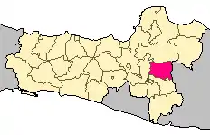 Location within Central Java | |
| Coordinates: 7°24′46″S 110°56′06″E / 7.4128°S 110.9350°E | |
| Country | Indonesia |
| Region | Java |
| Province | Central Java |
| Capital | Sragen |
| Government | |
| • Regent | Kusdinar Untung Yuni Sukowati |
| • Vice Regent | Dedy Endriyatno |
| Area | |
| • Total | 994.57 km2 (384.01 sq mi) |
| Population (mid 2022 estimate)[1] | |
| • Total | 992,243 |
| • Density | 1,000/km2 (2,600/sq mi) |
| Time zone | UTC+7 (IWST) |
| Area code | (+62) 271 |
| Website | sragenkab |

Sragen Regency (Javanese: ꦑꦧꦸꦥꦠꦺꦤ꧀ꦱꦿꦒꦼꦤ꧀, romanized: Kabupatèn Sragèn) is a regency (Indonesian: kabupaten) in the eastern part of Central Java province in Indonesia. It covers an area of 994.57 km2 and had a population of 858,266 at the 2010 Census[2] and 976,951 at the 2020 Census;[3] the official estimate as at mid 2022 was 992,243 (comprising 494,252 males and 497,991 females).[1] Its capital is the town of Sragen, located about 30 km to the northeast of Surakarta. Sragen is bordered by East Java Province to the east.
Java's longest river, the Bengawan Solo River, flows through the fertile rice fields in the region. The archaeological excavation and UNESCO World Heritage Site Sangiran is located in Sragen.
Administrative Districts
Sragen Regency comprises twenty districts (kecamatan), tabulated below with their areas and their populations at the 2010 Census[2] and the 2020 Census,[3] together with the official estimates as at mid 2022.[1] The table also includes the locations of the district administrative centres, the number of administrative villages in each district (totaling 196 rural desa and 12 urban kelurahan), and its post code.
| Kode Wilayah | Name of District (kecamatan) | Area in km2 | Pop'n Census 2010 | Pop'n Census 2020 | Pop'n Estimate mid 2022 | Admin centre | No. of villages | Post code |
|---|---|---|---|---|---|---|---|---|
| 33.14.01 | Kalijambe | 48.47 | 47,135 | 52,619 | 53,442 | Banaran | 14 | 57275 |
| 33.14.02 | Plupuh | 50.41 | 42,394 | 50,897 | 51,693 | Sambirejo | 16 | 57283 |
| 33.14.03 | Masaran | 46.84 | 69,319 | 77,591 | 78,805 | Masaran | 13 | 57282 |
| 33.14.04 | Kedawung | 53.06 | 57,139 | 65,812 | 66,843 | Bendungan | 10 | 57292 |
| 33.14.05 | Sambirejo | 45.82 | 35,173 | 40,716 | 41,353 | Sambirejo | 9 | 57293 |
| 33.14.06 | Gondang | 46.83 | 41,454 | 47,085 | 47,822 | Gondang | 9 | 57254 |
| 33.14.07 | Sambungmacan | 43.81 | 43,907 | 48,466 | 49,225 | Banaran | 9 | 57253 |
| 33.14.08 | Ngrampal | 39.84 | 36,867 | 42,484 | 43,149 | Pilangsari | 8 | 57252 |
| 33.14.09 | Karangmalang | 46.01 | 62,367 | 73,120 | 74,265 | Puro | 10 (a) | 57221-57222 |
| 33.14.10 | Sragen (town) | 27.64 | 66,660 | 69,558 | 70,647 | Sragen Tengah | 8 (b) | 57211-57216 |
| 33.14.11 | Sidoharjo | 49.03 | 50,634 | 57,768 | 58,672 | Jetak | 12 | 57281 |
| 33.14.12 | Tanon | 52.69 | 50,631 | 58,590 | 59,507 | Gabugan | 16 | 57277 |
| 33.14.13 | Gemolong | 39.91 | 45,365 | 51,981 | 52,794 | Gemolong | 14 (c) | 57274 |
| 33.14.14 | Miri | 56.86 | 31,994 | 36,597 | 37,170 | Girimargo | 10 | 57276 |
| 33.14.15 | Sumberlawang | 79.43 | 43,525 | 50,032 | 50,816 | Ngandul | 11 | 57272 |
| 33.14.16 | Mondokan | 50.73 | 33,350 | 38,981 | 39,592 | Kedawung | 9 | 57271 |
| 33.14.17 | Sukodono | 47.48 | 29,108 | 33,370 | 33,893 | Majenang | 9 | 57263 |
| 33.14.18 | Gesi | 40.81 | 19,558 | 22,760 | 23,116 | Gesi | 7 | 57262 |
| 33.14.19 | Tangen | 56.92 | 25,591 | 29,117 | 29,572 | Katelan | 7 | 57261 |
| 33.14.20 | Jenar | 71.98 | 26,100 | 29,407 | 29,867 | Dawung | 7 | 57256 |
| Totals | 994.57 | 858,266 | 976,951 | 992,243 | Sragen | 208 |
Notes: (a) including 2 kelurahan (Kroyo and Plumbungan). (b) comprising 6 kelurahan (Karang Tengah, Nglorog, Sine, Sragen Kulon, Sragen Tengah and Sragen Wetan) and 2 desa. (c) including 4 kelurahan (Gemolong, Kragilan. Kwangen and Ngembat Padas).
Climate
Sragen has a tropical monsoon climate (Am) with moderate to little rainfall from June to September and heavy rainfall from October to May.
| Climate data for Sragen | |||||||||||||
|---|---|---|---|---|---|---|---|---|---|---|---|---|---|
| Month | Jan | Feb | Mar | Apr | May | Jun | Jul | Aug | Sep | Oct | Nov | Dec | Year |
| Mean daily maximum °C (°F) | 30.8 (87.4) |
30.7 (87.3) |
31.0 (87.8) |
31.7 (89.1) |
31.4 (88.5) |
31.5 (88.7) |
31.6 (88.9) |
32.4 (90.3) |
33.4 (92.1) |
33.7 (92.7) |
32.8 (91.0) |
31.7 (89.1) |
31.9 (89.4) |
| Daily mean °C (°F) | 26.5 (79.7) |
26.5 (79.7) |
26.6 (79.9) |
27.0 (80.6) |
26.6 (79.9) |
26.1 (79.0) |
25.6 (78.1) |
26.0 (78.8) |
26.9 (80.4) |
27.6 (81.7) |
27.5 (81.5) |
26.9 (80.4) |
26.6 (80.0) |
| Mean daily minimum °C (°F) | 22.2 (72.0) |
22.3 (72.1) |
22.3 (72.1) |
22.3 (72.1) |
21.8 (71.2) |
20.7 (69.3) |
19.6 (67.3) |
19.6 (67.3) |
20.5 (68.9) |
21.6 (70.9) |
22.2 (72.0) |
22.2 (72.0) |
21.4 (70.6) |
| Average rainfall mm (inches) | 305 (12.0) |
307 (12.1) |
319 (12.6) |
213 (8.4) |
149 (5.9) |
63 (2.5) |
58 (2.3) |
32 (1.3) |
52 (2.0) |
144 (5.7) |
226 (8.9) |
260 (10.2) |
2,128 (83.9) |
| Source: Climate-Data.org[4] | |||||||||||||
References
External links
Regencies and cities of Central Java | ||
|---|---|---|
Capital: Semarang | ||
| Regencies |  | |
| Cities | ||
7°24′46″S 110°56′06″E / 7.4128°S 110.9350°E