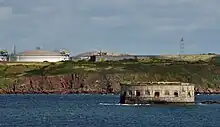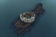
Stack Rock Fort is a fort built on a small island in the Milford Haven Waterway, Pembrokeshire, Wales. A 3-gun fort was built between 1850 and 1852, and then upgraded from 1859 to 1871 with a new building that completely encased the original gun tower. It is now a Grade II* listed building[1] and a scheduled monument (registered SAM number PE334).
History


A fortification at Stack Rock was first proposed by Thomas Cromwell in 1539 to protect the waterway, although this would not actually come to fruition at the time. Similar proposals were made in 1748 when Lewis Morris carried out a survey of Milford Haven, reporting on shipwrecks and navigation and recommending that a small fort be built here. Another survey followed in 1817. The Royal Dockyard at Pembroke Dock was felt to be in need of defence from the sea,[2] The result was a tower mounting three guns, similar to the two towers in Pembroke Dock.[3] The tower was oval in section, with a maximum diameter of 55 feet (17 m) and a maximum height of 30 feet (9.1 m).[4] Construction commenced in 1850, being completed in 1852.[5]
In 1858, the first appearance of the French ironclad Gloire rendered the tower and its guns obsolete, so it was decided to completely surround it with a new battery. The original design was for two decks each of 19 casemates and 16 open air guns above, 54 guns in total, and built mainly of limestone. However, after the foundations had been started in 1861, the design was amended to have stronger granite piers supporting iron gun shields. The basements and magazines had been completed in 1863, when the design was altered again, for 16 large guns on a single floor of casemates in the front and seven smaller guns on two floors in the gorge, the rear of the fort facing into the Haven. The top floor was built as accommodation intended for 4 officers and 152 men. On the roof of the fort, three gun turrets each with two huge RML 12-inch 25-ton gun were planned, but never installed. This scheme was finally completed in 1871.[3] The usual peacetime garrison was one officer and thirty men.[5] Disarmed in 1929, it was first placed on the market in 1932 and sold for £160.[5] In 2005 it was sold once more for £150,000.[6]
Concerns over the security of a nearby LNG jetty were raised in 2013, following the discovery of potential trespasser activity.[7]
The fort was sold again in 2020 to a private owner for an undisclosed amount. Land Registry records show[8] that it was sold in January 2021 for £191,000 to community interest company (CIC) Anoniiem.[9]
Armament
The original tower housed three 32-pounder guns, as well as a single 12-pounder for protection of the walls of the dock. From 1859 to 1871, the armaments were changed to sixteen 10-inch and seven 9-inch Rifled Muzzle Loaders. These were replaced with four 12-pounder QF (quick firing) guns in 1902. A small number of men manned the fort during World War I and by this time, only two 12-pounder QF guns remained.[2]
References
- ↑ "Stack Rock Fort, Herbrandston". British Listed Buildings. Retrieved 1 June 2011.
- 1 2 Alan Phillips (2013). Castles and Fortifications of Wales. Amberley Publishing Limited. p. 109. ISBN 978-1-4456-2484-6.
- 1 2 "Full Report for Listed Buildings - Stack Rock Fort - 82592". cadwpublic-api.azurewebsites.net. Cadw. Retrieved 3 August 2023.
- ↑ Clements, William H (1999). Towers of Strength: Martello Towers Worldwide. Barnsley, South Yorkshire: Pen & Sword Books Ltd. p. 132. ISBN 978-0850526844.
- 1 2 3 Phillips, Benjamin A Pembrokeshire's Forts & Military Airfields 1535–2010, Logaston Press, 2013 ISBN 9781906663735
- ↑ Island Fort For Sale At £150,000 BBC News Article, 25 June 2005
- ↑ Sinclair, Thomas (26 August 2013). "Stack Rock 'break-in' raises LNG safety concerns". The Pembrokeshire Herald. Retrieved 6 March 2023.
- ↑ Title Number WA771021
- ↑ "Stack Rock Fort: Victorian island reclaimed by nature". BBC News. 28 July 2023. Retrieved 31 July 2023.