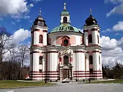
Stadl-Paura | |
|---|---|
 Church of Holy Trinity | |
 Coat of arms | |
 Stadl-Paura Location within Austria | |
| Coordinates: 48°05′02″N 13°51′50″E / 48.08389°N 13.86389°E | |
| Country | Austria |
| State | Upper Austria |
| District | Wels-Land |
| Government | |
| • Mayor | Christian Popp (FPÖ) |
| Area | |
| • Total | 15.05 km2 (5.81 sq mi) |
| Elevation | 360 m (1,180 ft) |
| Population (2018-01-01)[2] | |
| • Total | 5,053 |
| • Density | 340/km2 (870/sq mi) |
| Time zone | UTC+1 (CET) |
| • Summer (DST) | UTC+2 (CEST) |
| Postal code | 4651 |
| Area code | 07245 |
| Vehicle registration | WL |
| Website | www.stadl-paura.at |
Stadl-Paura is a municipality in the Austrian state of Upper Austria located in the district Wels-Land. About half of it lies in the Hausruckviertel, the other half in the Traunviertel. Despite this fact the whole district Wels-Land is officially seen as a part of the Hausruckviertel.
| Population development | |||||||||
|---|---|---|---|---|---|---|---|---|---|
| Year | Inhabitants | Change% | |||||||
| 1869 | 2.625 | --- | |||||||
| 1880 | 2.421 | -7,8 | |||||||
| 1890 | 2.601 | +7,4 | |||||||
| 1900 | 2.672 | +2,7 | |||||||
| 1910 | 2.840 | +6,3 | |||||||
| 1923 | 2.905 | +2,3 | |||||||
| 1934 | 3.155 | +8,6 | |||||||
| 1939 | 2.976 | -5,7 | |||||||
| 1951 | 6.093 | +104,7 | |||||||
| 1961 | 4.691 | -23,0 | |||||||
| 1971 | 4.841 | +3,2 | |||||||
| 1981 | 4.744 | -2,0 | |||||||
| 1991 | 4.838 | +2,0 | |||||||
| 2001 | 4.866 | +0,6 | |||||||
References
- ↑ "Dauersiedlungsraum der Gemeinden Politischen Bezirke und Bundesländer - Gebietsstand 1.1.2018". Statistics Austria. Retrieved 10 March 2019.
- ↑ "Einwohnerzahl 1.1.2018 nach Gemeinden mit Status, Gebietsstand 1.1.2018". Statistics Austria. Retrieved 9 March 2019.
This article is issued from Wikipedia. The text is licensed under Creative Commons - Attribution - Sharealike. Additional terms may apply for the media files.