Stary Sącz | |
|---|---|
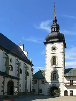
 Poor Clare Nuns monastery in Stary Sącz | |
 Flag  Coat of arms | |
 Stary Sącz | |
| Coordinates: 49°33′45″N 20°38′11″E / 49.56250°N 20.63639°E | |
| Country | |
| Voivodeship | Lesser Poland |
| County | Nowy Sącz |
| Gmina | Stary Sącz |
| Town rights | 1257 |
| Government | |
| • Mayor | Jacek Lelek |
| Area | |
| • Total | 16.56 km2 (6.39 sq mi) |
| Elevation | 320 m (1,050 ft) |
| Population (2021) | |
| • Total | 9,211 |
| • Density | 560/km2 (1,400/sq mi) |
| Time zone | UTC+1 (CET) |
| • Summer (DST) | UTC+2 (CEST) |
| Postal code | 33-340 |
| Car plates | KNS |
| Website | http://www.stary.sacz.pl |
Stary Sącz [ˈstarɨ ˈsɔnt͡ʂ] is a small historic town in Lesser Poland Voivodeship of southern Poland. It is the seat of the Gmina Stary Sącz (commune), and one of the oldest towns in the country, having been founded in the 13th century.
Geography
Stary Sącz is located in bottom of the valley called Kotlina Sądecka, between two rivers - Dunajec and Poprad, at an altitude of 320 metres (1,050 feet) above sea level.
History
The history of the town dates back to the Early Middle Ages when Duchess Kinga (Kinga of Poland) the daughter of the King Béla IV of Hungary and the wife of Duke Bolesław V the Chaste, received the land called Sącz, together with surrounding villages, from her husband in the year 1257. It is assumed to be the date of the town foundation. Indeed, the Duchess must have loved the mountains very much, since she founded a Convent of the Poor Clares there in 1280 and she became its duchess herself. Almost at the same time, on the opposite slope of the Sącz hill, the seat of a Franciscan order was established also by Duchess Kinga. In the year 1358 the town received a privilege of the Magdeburg law, confirmed by King Casimir III the Great. An extremely advantageous location, on a very busy trade route to Hungary, fostered the town's rapid development. However the town was often damaged by disasters, of which fires were the most harmful. The town also did not manage to escape floods, plagues and wars. During the biggest fire, in 1795, almost the entire town burned down.
Tourism, recreation and sport
Stary Sącz has unique medieval architecture and many monuments of ecclesiastical buildings.
At the fork of the rivers Dunajec and Poprad is a recreation area with a few ponds. (Their overall surface-area is 14 ha (35 acres)). These ponds contain numerous fish, including carp, trout and sanders, and rainbow trout in a special fishery.
Stary Sącz, situated in the lag of the Poprad Landscape Park is also the seat of the Park Service. One of Poland's biggest landscape parks stretches all over the range of the mountains Radziejowa and Jaworzyna in the Beskid Sądecki region.
There are several hiking trails in the area, some of which start in Stary Sącz. These include:
- The Yellow Route: from the railway station in Stary Sącz via Moszczenica, Przysietnica into the Radziejowa range, where, on the Przehyba summit (1,175 m (3,855 ft)), it joins The Red Route heading towards Krościenko.
- The Blue Route: begins at the railway station in Barcice and via Wola Krogulecka climbs the Makowica summit (948 m (3,110 ft)).
A bike route goes from Stary Sącz to the Przehyba summit via Gołkowice and Skrudzina.
Many sporting event take place in Stary Sącz. Some of the most well attended are:
External links
- Jewish Community in Stary Sącz on Virtual Shtetl