Stetten | |
|---|---|
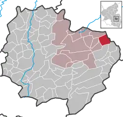
Location of Stetten within Donnersbergkreis district  | |
 Stetten  Stetten | |
| Coordinates: 49°40′19″N 8°5′38″E / 49.67194°N 8.09389°E | |
| Country | Germany |
| State | Rhineland-Palatinate |
| District | Donnersbergkreis |
| Municipal assoc. | Kirchheimbolanden |
| Government | |
| • Mayor (2019–24) | Kai Uwe Angermayer[1] |
| Area | |
| • Total | 6.54 km2 (2.53 sq mi) |
| Elevation | 235 m (771 ft) |
| Population (2021-12-31)[2] | |
| • Total | 665 |
| • Density | 100/km2 (260/sq mi) |
| Time zone | UTC+01:00 (CET) |
| • Summer (DST) | UTC+02:00 (CEST) |
| Postal codes | 67294 |
| Dialling codes | 06355 |
| Vehicle registration | KIB |
| Website | www.kirchheimbolanden.de |
Stetten is a municipality in Rhineland-Palatinate, Germany. It is in the Kirchheimbolanden Verbandsgemeinde (administrative unit).
History
The first documented record of Stetten occurred in 835.
Stetten was very badly damaged by 1635 due to the Thirty Years' War.
The region of Stetten, Palatinate was previously a district of the Kingdom of Bavaria. It became part of Rhineland-Palatinate in 1946.
References
- ↑ Direktwahlen 2019, Donnersbergkreis, Landeswahlleiter Rheinland-Pfalz, accessed 9 August 2021.
- ↑ "Bevölkerungsstand 2021, Kreise, Gemeinden, Verbandsgemeinden" (in German). Statistisches Landesamt Rheinland-Pfalz. 2022.
External links
- www.kirchheimbolanden.de — official website (in German)
- www.ngw.nl — coat of arms
- www.tus-stetten.de — TuS 1860 Stetten/Pfalz e. V. (in German)
This article is issued from Wikipedia. The text is licensed under Creative Commons - Attribution - Sharealike. Additional terms may apply for the media files.