| Stoney Indian Peaks | |
|---|---|
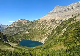 Stoney Indian Peaks at right above Stoney Indian Lake | |
| Highest point | |
| Elevation | 9,355 ft (2,851 m)[1] |
| Prominence | 830 ft (250 m)[1] |
| Coordinates | 48°53′55″N 113°51′30″W / 48.89861°N 113.85833°W[2] |
| Geography | |
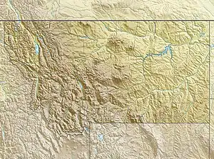 Stoney Indian Peaks Location in Montana  Stoney Indian Peaks Location in the United States | |
| Location | Glacier County, Montana, U.S. |
| Parent range | Lewis Range |
| Topo map | USGS Mount Cleveland, MT |
Stoney Indian Peaks (9,355 feet (2,851 m)) are located in the Lewis Range, Glacier National Park in the U.S. state of Montana.[3] Consisting of several summits, the mountain is in the northeastern region of Glacier National Park, less than 2 miles (3.2 km) south of Mount Cleveland. Stoney Indian Lake is south of the peaks.
See also
References
- 1 2 "Stoney Indian Peaks, Montana". Peakbagger.com. Retrieved December 27, 2018.
- ↑ "Stoney Indian Peaks". Geographic Names Information System. United States Geological Survey, United States Department of the Interior. Retrieved December 27, 2018.
- ↑ Mount Cleveland, MT (Map). TopoQwest (United States Geological Survey Maps). Retrieved December 27, 2018.

Stoney Indian Peaks at sunset
This article is issued from Wikipedia. The text is licensed under Creative Commons - Attribution - Sharealike. Additional terms may apply for the media files.