| Strathbogie Victoria | |||||||||
|---|---|---|---|---|---|---|---|---|---|
 Main street of Strathbogie | |||||||||
 Strathbogie | |||||||||
| Coordinates | 36°51′S 145°44′E / 36.850°S 145.733°E | ||||||||
| Population | 304 (2016 census)[1] | ||||||||
| Postcode(s) | 3666 | ||||||||
| Elevation | 502 m (1,647 ft) | ||||||||
| Location | |||||||||
| LGA(s) | Shire of Strathbogie | ||||||||
| State electorate(s) | Euroa | ||||||||
| Federal division(s) | Indi | ||||||||
| |||||||||
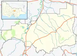
Strathbogie is a town in central Victoria, Australia. It is in the Shire of Strathbogie local government area. At the 2016 census, Strathbogie and the surrounding area had a population of 304.[1]
The Post Office opened on 10 July 1878.[2]
Golfers play at the course of the Strathbogie Golf Club on Armstrong Avenue.[3]
Strathbogie is located in the Strathbogie Ranges. Mount Wombat (799 metres), which includes a floral and fauna reserve, is 4.6 km. to the north-west.
Town facilities include a general store/ cafe, war memorial and recreation reserve.
Climate
Strathbogie has warm, dry summers, though which are frequently interrupted by cold fronts on account of its proximity to the Southern Ocean (typical of Central Victoria); summer maximum temperatures have been as cold as 9.7 °C (49.5 °F) on 01 December 2019, and on 03 February 2005 the maximum did not exceed 10.5 °C (50.9 °F).
A pronounced autumnal lag is noted (March being almost as warm as December), and the winters are cool and rainy with many occurrences of snowfall. It has a Mediterranean rainfall pattern, with nearly thrice the rainfall in winter than in high summer.
| Climate data for Strathbogie (1974–2022, rainfall to 1902); 501 m AMSL; 36.85° S, 145.73° E | |||||||||||||
|---|---|---|---|---|---|---|---|---|---|---|---|---|---|
| Month | Jan | Feb | Mar | Apr | May | Jun | Jul | Aug | Sep | Oct | Nov | Dec | Year |
| Record high °C (°F) | 42.0 (107.6) |
42.0 (107.6) |
36.3 (97.3) |
32.5 (90.5) |
23.0 (73.4) |
19.1 (66.4) |
18.5 (65.3) |
22.0 (71.6) |
26.8 (80.2) |
31.0 (87.8) |
37.2 (99.0) |
39.1 (102.4) |
42.0 (107.6) |
| Mean daily maximum °C (°F) | 27.5 (81.5) |
27.3 (81.1) |
24.0 (75.2) |
18.9 (66.0) |
14.4 (57.9) |
11.2 (52.2) |
10.2 (50.4) |
11.5 (52.7) |
14.3 (57.7) |
18.0 (64.4) |
21.6 (70.9) |
24.8 (76.6) |
18.6 (65.6) |
| Mean daily minimum °C (°F) | 11.7 (53.1) |
11.6 (52.9) |
9.2 (48.6) |
5.7 (42.3) |
3.6 (38.5) |
2.0 (35.6) |
1.8 (35.2) |
2.3 (36.1) |
3.7 (38.7) |
5.3 (41.5) |
7.6 (45.7) |
9.4 (48.9) |
6.2 (43.1) |
| Record low °C (°F) | 0.0 (32.0) |
1.2 (34.2) |
−0.5 (31.1) |
−3.6 (25.5) |
−5.7 (21.7) |
−7.2 (19.0) |
−8.0 (17.6) |
−6.0 (21.2) |
−5.5 (22.1) |
−3.0 (26.6) |
−3.0 (26.6) |
−1.0 (30.2) |
−8.0 (17.6) |
| Average precipitation mm (inches) | 49.1 (1.93) |
43.5 (1.71) |
57.0 (2.24) |
66.4 (2.61) |
95.0 (3.74) |
113.5 (4.47) |
121.6 (4.79) |
114.9 (4.52) |
94.0 (3.70) |
85.4 (3.36) |
64.0 (2.52) |
58.0 (2.28) |
962.6 (37.90) |
| Average precipitation days (≥ 0.2 mm) | 5.3 | 4.6 | 5.6 | 7.2 | 11.4 | 13.2 | 15.2 | 14.5 | 12.1 | 10.5 | 8.2 | 6.5 | 114.3 |
| Average afternoon relative humidity (%) | 40 | 39 | 45 | 54 | 67 | 74 | 75 | 69 | 63 | 57 | 49 | 42 | 56 |
| Source: Australian Bureau of Meteorology; Strathbogie | |||||||||||||
References
- 1 2 "2016 Census QuickStats Strathbogie". Australian Bureau of Statistics. Retrieved 13 July 2018.
- ↑ Phoenix Auctions History, Post Office List, retrieved 11 March 2021
- ↑ Golf Select, Strathbogie, retrieved 11 May 2009
External links
![]() Media related to Strathbogie, Victoria at Wikimedia Commons
Media related to Strathbogie, Victoria at Wikimedia Commons