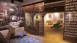
The Strindberg Museum Saxen is located in the village Saxen in Upper Austria. It is the only Strindberg museum outside of Sweden and is managed by the Kulturverein Saxen.
Description
In 1997 the museum was founded in 1997 by Friedrich Buchmayr and the community of Saxen.
In 1893 August Strindberg married the Austrian author and translator Frida Uhl, and between 1893 and 1896 he stayed several times with her and their child Kerstin in Saxen and Klam. First they lived in the castle Dornach or in a building adjacent to the castle respectively. After controversies with Fridas family and Frida herself, he moved to Klam, a neighbouring place of Saxen, where he took the so-called Rosenzimmer in the inn Kirchenwirt.[1]
The museum displays original letters and manuscripts, contemporary photographs and a piano purchased by August Strindberg himself.
In the surroundings of Klam August Strindberg found a lot of themes for his paintings, e.g. the cascades in the canyon between Klam and Saxen, as well as for his novels where he depicted for example the stone formations, the hammer mill and a pigsty in the canyon. In the fifteenth chapter of his novel Inferno he describes his visions having experienced during a walk through the canyon.
In 2009 the Strindberg walk between Saxen and Klam was provided with signs.[2]
Awards
- Upper Austrian museum of the month in May 2007 [3]
- Strindberg award 1998 granted by the Strindberg Museum in Stockholm [4]
External links
- homepage of the Strindberg museum in Saxen
- homepage of the Strindberg museum in Stockholm
- Gutenberg ebook The Inferno by August Strindberg
- Strindbergs inferno walk in different languages:
References
- ↑ Heinz Gerstinger: Österreich – Holdes Märchen und böser Traum. August Strindbergs Ehe mit Frida Uhl. Herold Wien 1987, ISBN 3-7008-0296-X at Österreichische Nationalbibliothek
- ↑ Arge Strindbergweg-Klamschlucht, Marktgemeinden Klam und Saxen, Folder Klamschlucht und Strindbergweg, Grein, 2009 PDF
- ↑ Strindbergmuseum zum Museum des Monats gewählt, in: Perger Tips, May 9th 2007
- ↑ Österreichische Kultur im Norden, Österreichische Kulturarbeit in Schweden, in: Ausblicke 15, Zeitschrift für österreichische Kultur und Sprache, 8. Jahrgang, May 2002, pages 18f