| Stubai Hohenweg | |
|---|---|
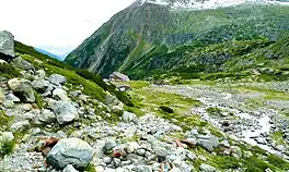 Sulzenau hut on the Stubai trail | |
| Length | 120 kilometres (70 mi) approximately |
| Location | Tyrol, Austria |
| Use | Hiking |
| Highest point | 2,858 m (9,377 ft) |
| Difficulty | Difficult |
| Season | Summer to early autumn |
| Months | Mid-June to early October |
The Stubai Hohenweg or Stubai highroute is a high-level footpath in Tyrol, Austria. It is approximately 80 km long, and a total ascent / descent of over 6,000 m.[1] The trail can be completed in 8 or 9 days. It is designed to be a circular route around the Stubai valley. The trail starts in Neustift, but can be started from any hut on the trail, for example Fulpmes.[2]
The path is by alpine and high alpine terrain, between 2000 and 3000 m. Some sections are secured by cable, but the route avoids glaciers.[3]
The difficulty level of the trail is "black", namely the hiker would encounter narrow, steep and exposed paths. For this reason, good physical fitness, freedom from vertigo and surefootedness are required.[1]
Stages
| Start | Finish | Time | Related summits | |
|---|---|---|---|---|
| 1 | Fulpmes/Kreuzjoch | Starkenburger Hut | 1,5 h | Schlicker Seespitze (2.804 m, 3 h) |
| 2 | Starkenburger Hütte | Franz Senn Hut | 6 h | Rinnenspitze (3.000 m, 3 h) Aperer Turm (2.986 m, 3,5 h) |
| 3 | Franz-Senn-Hütte | Neue Regensburger Hut | 4 h | Ruderhofspitze (3.474 m, 4,5 h) Östliche Knotenspitze (3.101 m, 2,5 h) |
| 4 | Neue Regensburger Hütte | Dresdner Hut | 6 h | Zuckerhütl (3.507 m, 4,5 h) Stubaier Wildspitze (3.341 m, 3 h) |
| 5 | Dresdner Hütte | Sulzenau Hut | 2,5 h (über Peiljoch, 2.672 m) 3,5 h (über Großer Trögler, 2.902 m) | Zuckerhütl (3.507 m, 5 h) Wilder Freiger (3.418 m, 4 h) |
| 6 | Sulzenau Hütte | Nurnberger Hut | 3 h (über Niederl, 2.629 m) 3,5 h (über Mairspitze, 2.743 m) | Wilder Freiger (3.418 m, 4 h) Östlicher Feuerstein (3.267 m, 4 h) |
| 7 | Nürnberger Hütte | Bremer Hütte | 3 h | Innere Wetterspitze (3.053 m, 1,5 h) |
| 8 | Bremer Hütte | Innsbrucker Hütte | 7 h | Habicht (3.277 m, 2,5 h) Kalkwand (2.564 m, 1 h) |
| 9 | Innsbrucker Hütte | Neustift | 4 h | Elferspitze (2.505 m) |
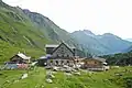 Franz-Senn-Hütte
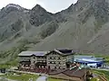 Dresdner Hütte
.jpg.webp) Nürnberger Hütte
Nürnberger Hütte.jpg.webp) Bremer Hütte
Bremer Hütte
References
External links
This article is issued from Wikipedia. The text is licensed under Creative Commons - Attribution - Sharealike. Additional terms may apply for the media files.