Stubbs, Kansas | |
|---|---|
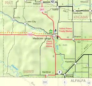 KDOT map of Barber County (legend) | |
 Stubbs  Stubbs | |
| Coordinates: 37°00′24″N 98°33′57″W / 37.00667°N 98.56583°W[1] | |
| Country | United States |
| State | Kansas |
| County | Barber |
| Elevation | 1,378 ft (420 m) |
| Time zone | UTC-6 (CST) |
| • Summer (DST) | UTC-5 (CDT) |
| Area code | 620 |
| FIPS code | 20-68675 [1] |
| GNIS ID | 484526 [1] |
Stubbs is an unincorporated community in Barber County, Kansas, United States.[1] It is 4.5 miles (7.2 km) west of Kiowa.
References
Further reading
External links
Municipalities and communities of Barber County, Kansas, United States | ||
|---|---|---|
| Cities | 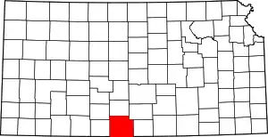 Map of Kansas highlighting Barber County | |
| Unincorporated communities | ||
| Townships | ||
| Footnotes | †This community is designated a Census-Designated Place (CDP) by the United States Census Bureau. | |
This article is issued from Wikipedia. The text is licensed under Creative Commons - Attribution - Sharealike. Additional terms may apply for the media files.