Su-ngai Kolok
สุไหงโก-ลก | |
|---|---|
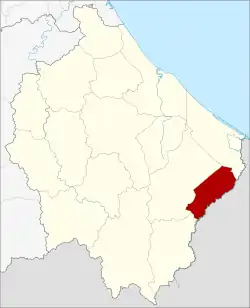 District location in Narathiwat province | |
| Coordinates: 6°1′46″N 101°57′58″E / 6.02944°N 101.96611°E | |
| Country | Thailand |
| Province | Narathiwat |
| Seat | Su-ngai Kolok |
| Area | |
| • Total | 138.3 km2 (53.4 sq mi) |
| Population (2005) | |
| • Total | 69,757 |
| • Density | 504.4/km2 (1,306/sq mi) |
| Time zone | UTC+7 (ICT) |
| Postal code | 96120 |
| Geocode | 9610 |
Su-ngai Kolok (Thai: สุไหงโก-ลก, pronounced [sū.ŋǎj kōː.lók]) is a district (amphoe) of Narathiwat province, southern Thailand.
History
The minor district (king amphoe) was created on 2 January 1948, consisting of the three tambons: Su-ngai Kolok, Puyo, and Pase Mat from Su-ngai Padi district and Muno from Tak Bai district.[1] In 1953 it was upgraded to a full district.[2]
Geography
Neighboring districts are (from the southwest clockwise) Waeng, Su-ngai Padi and Tak Bai. To the southeast is the state Kelantan of Malaysia.
The main water resource is the Kolok River.
Administration
The district is divided into four sub-districts (tambons), which are further subdivided into 19 villages (mubans). Su-ngai Kolok itself has town (thesaban mueang) status and covers most parts of the same-named tambon.
| No. | Name | Thai name | Villages | Pop. | |
|---|---|---|---|---|---|
| 1. | Su-ngai Kolok | สุไหงโก-ลก | 1 | 38,756 | |
| 2. | Pase Mat | ปาเสมัส | 7 | 16,765 | |
| 3. | Muno | มูโนะ | 5 | 8,553 | |
| 4. | Puyo | ปูโยะ | 6 | 5,683 |
References
- ↑ ประกาศกระทรวงมหาดไทย เรื่อง ยกฐานะตำบลขึ้นเป็นกิ่งอำเภอ (PDF). Royal Gazette (in Thai). 64 (60 ง): 3288–3293. December 9, 1947. Archived from the original (PDF) on November 9, 2011.
- ↑ พระราชกฤษฎีกาจัดตั้งอำเภอจักราช อำเภอสัตตหีบ อำเภอศรีสงคราม อำเภอชะอวด อำเภอหนองแซง อำเภอภาชี อำเภอเขาไชยสน อำเภอชุมพลบุรี อำเภอวาริชภูมิ อำเภอสบปราบ และอำเภอสุไหงโกลก พ.ศ. ๒๔๙๖ (PDF). Royal Gazette (in Thai). 70 (17 ก): 368–371. March 10, 1953. Archived from the original (PDF) on April 6, 2012.
External links