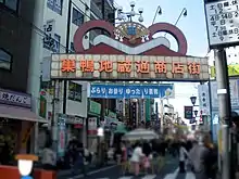
Sugamo (巣鴨) is a neighborhood in Toshima, Tokyo, Japan. It is home to Jizō-dōri (地蔵通り), a shopping street popular among the older generation, earning it the nickname "Granny's Harajuku."[1][2] It lies at the crossing point of the JR Yamanote Line and National Route 17.
Available public transportation to Sugamo are JR Yamanote Line and Toei Mita Line.[3] There is also Koshinzuka station of Toden Arakawa Line in the middle of Jizō-dōri (地蔵通り) shopping street.
Tokugawa Yoshinobu, who is the last shogun of the Tokugawa Shogunate set his residence here in 1897.[4][5] He has lived for 4 years there and moved away to avoid the noise coming from Yamanote Line.
Education
Public elementary and junior high schools are operated by the Toshima Ward Board of Education.
Sugamo is served by the attendance zones of multiple elementary schools:[6]
- Gyoko Elementary School (仰高小学校) - 2-chome, most of 1-chome and 3-chome
- Sugamo Elementary School (巣鴨小学校) - 1-chome 34-49-ban
- Seiwa Elementary School (清和小学校) - 3-chome 5-18 ban, 4-chome 1-26 and 33-ban and most of 28, 29, and 32-ban
- Asahi Elementary School (朝日小学校) - 5-chome, and 4-chome 27, 30-31, and 34-44-ban, and parts of 28, 29, and 32-ban
The following junior high schools serve portions of Sugamo:[6]
See also
References
- ↑ Nagamura, Kit (8 December 2017). "Warming to Sugamo's venerable shopping street". The Japan Times. Retrieved 22 April 2020.
- ↑ Saarinen, Ili (31 March 2017). "Why is Sugamo known as 'Harajuku for grannies'?". Time Out. Retrieved 22 April 2020.
- ↑ "keywords". 東京都交通局 (in Japanese). Retrieved 2022-06-07.
- ↑ "徳川慶喜巣鴨屋敷跡". www.yoritomo-japan.com. Retrieved 2022-06-10.
- ↑ "<豊島区>最後の将軍「徳川慶喜」が住んだ街:巣鴨|街紹介|オークラヤコラム|マンション売却・購入・住みかえ・賃貸ならオークラヤ住宅". マンション売却・購入・住みかえ・賃貸ならオークラヤ住宅 (in Japanese). Retrieved 2022-06-10.
- 1 2 "豊島区立小・中学校通学区域" (PDF). Toshima Ward. Retrieved 2022-10-08.
35°44′20″N 139°43′52″E / 35.73889°N 139.73111°E