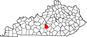
Summersville, Kentucky | |
|---|---|
 Businesses along KY 61 | |
 Summersville  Summersville | |
| Coordinates: 37°19′34″N 85°32′40″W / 37.32611°N 85.54444°W | |
| Country | United States |
| State | Kentucky |
| County | Green |
| Area | |
| • Total | 2.89 sq mi (7.49 km2) |
| • Land | 2.89 sq mi (7.48 km2) |
| • Water | 0.00 sq mi (0.01 km2) |
| Elevation | 804 ft (245 m) |
| Population (2020) | |
| • Total | 551 |
| • Density | 190.66/sq mi (73.62/km2) |
| Time zone | UTC-6 (Central (CST)) |
| • Summer (DST) | UTC-5 (CDT) |
| ZIP code | 42782 |
| FIPS code | 21-74604 |
| GNIS feature ID | 504784 |
Summersville is a census-designated place (CDP) and unincorporated community in Green County, Kentucky, United States. As of the 2010 census it had a population of 568.[2]
It lies along Routes 61 and 323, 6 miles (10 km) northwest of the city of Greensburg, the county seat of Green County.[3] Its elevation is 804 feet (245 m).[4] It has a post office with the ZIP code 42782.[5] Annually in late July the residents host a festival named "Summersville Days".
Summersville was incorporated in 1817.[6]
Demographics
| Census | Pop. | Note | %± |
|---|---|---|---|
| 2020 | 551 | — | |
| U.S. Decennial Census[7] | |||
References
- ↑ "2020 U.S. Gazetteer Files". United States Census Bureau. Retrieved March 18, 2022.
- ↑ "Geographic Identifiers: 2010 Demographic Profile Data (G001): Summersville CDP, Kentucky". American Factfinder. U.S. Census Bureau. Retrieved December 13, 2016.
- ↑ Rand McNally. The Road Atlas '06. Chicago: Rand McNally, 2006, p. 42.
- ↑ U.S. Geological Survey Geographic Names Information System: Summersville, Kentucky, Geographic Names Information System, 1979-09-20. Accessed 2007-12-31.
- ↑ USPS – Cities by ZIP Code
- ↑ Collins, Lewis (1877). History of Kentucky. p. 294.
- ↑ "Census of Population and Housing". Census.gov. Retrieved June 4, 2016.
External links
 Media related to Summersville, Kentucky at Wikimedia Commons
This article is issued from Wikipedia. The text is licensed under Creative Commons - Attribution - Sharealike. Additional terms may apply for the media files.
