Tablelands Highway | |
|---|---|
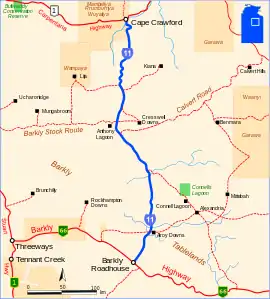 | |
| Tablelands Highway (depicted in blue) | |
| General information | |
| Type | Highway |
| Length | 375 km (233 mi) |
| Route number(s) | |
| Major junctions | |
| North end | |
| South end | |
| Location(s) | |
| Major settlements | Mallapunyah. Walhallow Station, Anthony Lagoon, Brunette Downs |
| Highway system | |
The Tablelands Highway is a 375 kilometre single lane sealed road in the Northern Territory, Australia. It runs from Barkly Homestead on the Barkly Highway to Cape Crawford near Borroloola on the Carpentaria Highway.[1][2]
Upgrades
The Northern Australia Beef Roads Program announced in 2016 included the following project for the Tablelands Highway.
Road upgrading
The project to upgrade selected sections to a two-lane sealed standard was completed in mid 2020 at a total cost of $25 million.[3]
See also
References
- ↑ Department of Transport (April 1998). "Map of all NT Roads" (PDF). Northern Territory Government. Archived from the original (PDF) on 5 May 2013. Retrieved 13 January 2014.
- ↑ Hema, Maps (2007). Australia Road and 4WD Atlas (Map). Eight Mile Plains Queensland: Hema Maps. pp. 11–12. ISBN 978-1-86500-456-3.
- ↑ "Tablelands Highway - Road Upgrading". Department of Infrastructure, Transport, Regional Development and Communications. 9 July 2020. Retrieved 30 March 2022.
Road infrastructure in Northern Territory | ||
|---|---|---|
| National highways | ||
| Highways | ||
| Major urban roads | ||
| Outback tracks and numbered state routes | ||
This article is issued from Wikipedia. The text is licensed under Creative Commons - Attribution - Sharealike. Additional terms may apply for the media files.