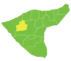
Tell Tamer Subdistrict
ناحية تل تمر | |
|---|---|
 Location of Tell Tamer Subdistrict within al-Hasakah Governorate | |
| Country | |
| Governorate | al-Hasakah |
| District | Al-Hasakah District, Al-Hasakah Governorate |
| Seat | Tell Tamer |
| Area | |
| • Total | 1,111.89 km2 (429.30 sq mi) |
| Population (2004)[1] | 50,982 |
| Geocode | SY080001 |
Tell Tamer Subdistrict (Arabic: ناحية تل تمر) is an ethnically Assyrian and Syriac subdistrict of al-Hasakah District in western al-Hasakah Governorate, northeastern Syria. The administrative centre is the city of Tell Tamer.
At the 2004 census, the subdistrict had a population of 50,982.[1] Assyrians from the Assyrian Church of the East constitute about 40% of the population of this district, with the rest being adherents of other Assyrian churches such as the Chaldean Catholic Church and Syriac Orthodox Church. There is also Kurds and Arabs. It is the headquarter of the Assyrian Khabour Guards and Nattoreh militias, as well as the location of a large Syriac Orthodox Monastery.
Cities, towns and villages
| PCode | Name | Population |
|---|---|---|
| C4409 | Tell Tamer | 7,285 |
| — | Ghabshah | 2,323 |
| — | Ein Eltineh | 1,653 |
| C4436 | Qaber Sghir | 1,594 |
| C4386 | Tawileh | 1,409 |
| C4416 | Fakkeh | 1,380 |
| C4435 | Mjeibret Zarkan | 1,334 |
| C4431 | Tell Jemaah | 1,260 |
| C4407 | Sukkar Elahimer | 1,181 |
| C4424 | Derdara | 1,140 |
| — | Rakaba | 1,136 |
| C4427 | Tell Hefyan | 1,132 |
| C4398 | Umm al-Keif | 1,072 |
| C4399 | al-Siha al-Wusta | 1,025 |
| — | ? | 933 |
| — | Umm Shaifa | 915 |
| — | al-Dawudiyah | 856 |
| C4430 | Tell Shamiram | 811 |
| C4408 | Tell Talaah | 800 |
| C4415 | Nayfeh | 763 |
| C4405 | Ghorra | 758 |
| — | Qaber Shamiyah | 734 |
| C4417 | Shmuka | 700 |
| C4391 | Jafr | 684 |
| C4421 | Tell Tawil | 669 |
| — | ? | 669 |
| C4426 | Abu Kabret | 667 |
| C4433 | Wadi Elnijmeh | 661 |
| C4411 | Hamaniyeh – Khirbat Eltamer | 653 |
| C4393 | Tell Nasri | 650 |
| C4429 | Tell Eljamiliyeh | 607 |
| C4419 | Tell Fweidat Shamiyeh | 587 |
| C4390 | Tell Hermez | 575 |
| C4418 | Khazneh Tal Tamr | 565 |
| C4402 | Qasemiyeh | 514 |
| C4434 | Kun Attar | 501 |
| — | al-Juwaysh | 501 |
| — | ? | 493 |
| C4400 | Tell Hammam Gharbi | 472 |
| C4387 | Tell Hammam Sharqi | 461 |
| C4403 | Salmasa | 448 |
| C4401 | Tell Balouaah | 443 |
| — | Tell Fuweidat Jazira | 439 |
| C4414 | Bab Elfaraj | 409 |
| C4437 | Madineh Qabliyeh | 404 |
| C4422 | Tell Ruman | 354 |
| — | al-Siha | 342 |
| — | Wadi al-Ahmar | 323 |
| — | Tell Tal | 314 |
| C4392 | Tell Sakra | 307 |
| C4410 | Abu Tinah | 301 |
| C4428 | Tell Jedaya | 301 |
| — | Khirbat Shaib | 289 |
| — | Umm Ghargan | 275 |
| C4404 | Tell Baz | 251 |
| C4413 | Tell Elmoghor | 249 |
| C4423 | Tell Massas | 231 |
| C4420 | Tell Arboush | 229 |
| C4385 | Maqbara | 221 |
| C4396 | Tell Nijmeh | 210 |
| C4389 | Umm al-Masamir | 197 |
| — | al-Husainiyah Sharqi | 197 |
| C4395 | Mutawaseta | 194 |
| C4394 | Tell Maghas | 194 |
| — | Tell Jazira | 190 |
| — | Tell Goran | 183 |
| C4412 | Tell Kifji | 181 |
| C4384 | al-Rihaniya Gharbi | 164 |
| C4388 | Tell Shamah | 162 |
| C4397 | Tell Damshij | 153 |
| — | al-Huda | 135 |
| C4406 | Beida | 127 |
| — | al-Mabattuh | 120 |
| C4432 | al-Kharitah | 111 |
| — | Tell Bureij | 109 |
| C4425 | Tell Makhadah | 72 |
| — | al-Siha al-Shamalia | 30 |
References
- 1 2 "2004 Census Data for Nahiya Tell Tamer" (in Arabic). Syrian Central Bureau of Statistics. Retrieved 15 October 2015. Also available in English: "2004 Census Data". UN OCHA. Retrieved 15 October 2015.
This article is issued from Wikipedia. The text is licensed under Creative Commons - Attribution - Sharealike. Additional terms may apply for the media files.