Three Rivers, Michigan | |
|---|---|
City | |
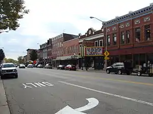
 Downtown Three Rivers | |
 Flag | |
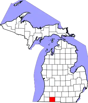
 Location of Three Rivers, Michigan | |
| Coordinates: 41°56′39″N 85°37′56″W / 41.94417°N 85.63222°W | |
| Country | United States |
| State | Michigan |
| County | St. Joseph |
| Area | |
| • Total | 5.83 sq mi (15.10 km2) |
| • Land | 5.56 sq mi (14.40 km2) |
| • Water | 0.27 sq mi (0.70 km2) |
| Elevation | 804 ft (245 m) |
| Population (2020) | |
| • Total | 7,973 |
| • Density | 1,433.73/sq mi (553.55/km2) |
| Time zone | UTC−5 (Eastern (EST)) |
| • Summer (DST) | UTC−4 (EDT) |
| ZIP code | 49093[2] |
| Area code | 269 |
| FIPS code | 26-79760[3] |
| GNIS feature ID | 1624987[4] |
| Website | City website |
Three Rivers is a city in St. Joseph County, Michigan. The population was 7,973 at the time of the 2020 census.[5]
Three Rivers derives its name from its location at the confluence of the St. Joseph River and two tributaries, the Rocky and Portage rivers.[6] The St. Joseph River flows into Lake Michigan.
The city is the home of St. Gregory's Abbey, a Benedictine monastery of the Episcopal Church, which was established in 1946.
Geography
According to the United States Census Bureau, the city has a total area of 5.66 square miles (14.66 km2), of which 5.40 square miles (13.99 km2) is land and 0.26 square miles (0.67 km2) is water.[7]
Highways
Climate
| Climate data for Three Rivers, Michigan (1991–2020 normals, extremes 1895–present) | |||||||||||||
|---|---|---|---|---|---|---|---|---|---|---|---|---|---|
| Month | Jan | Feb | Mar | Apr | May | Jun | Jul | Aug | Sep | Oct | Nov | Dec | Year |
| Record high °F (°C) | 67 (19) |
74 (23) |
83 (28) |
88 (31) |
97 (36) |
104 (40) |
107 (42) |
100 (38) |
103 (39) |
93 (34) |
81 (27) |
72 (22) |
107 (42) |
| Mean daily maximum °F (°C) | 31.2 (−0.4) |
34.4 (1.3) |
45.0 (7.2) |
57.8 (14.3) |
69.4 (20.8) |
78.6 (25.9) |
82.3 (27.9) |
80.2 (26.8) |
74.1 (23.4) |
61.2 (16.2) |
47.4 (8.6) |
36.1 (2.3) |
58.1 (14.5) |
| Daily mean °F (°C) | 23.9 (−4.5) |
26.1 (−3.3) |
35.4 (1.9) |
47.0 (8.3) |
58.5 (14.7) |
67.9 (19.9) |
71.4 (21.9) |
69.6 (20.9) |
62.6 (17.0) |
50.7 (10.4) |
39.1 (3.9) |
29.4 (−1.4) |
48.5 (9.2) |
| Mean daily minimum °F (°C) | 16.7 (−8.5) |
17.8 (−7.9) |
25.9 (−3.4) |
36.2 (2.3) |
47.6 (8.7) |
57.2 (14.0) |
60.5 (15.8) |
58.9 (14.9) |
51.0 (10.6) |
40.2 (4.6) |
30.9 (−0.6) |
22.8 (−5.1) |
38.8 (3.8) |
| Record low °F (°C) | −23 (−31) |
−20 (−29) |
−11 (−24) |
7 (−14) |
23 (−5) |
34 (1) |
41 (5) |
35 (2) |
25 (−4) |
13 (−11) |
−6 (−21) |
−15 (−26) |
−23 (−31) |
| Average precipitation inches (mm) | 2.85 (72) |
2.06 (52) |
2.30 (58) |
3.35 (85) |
4.40 (112) |
4.10 (104) |
3.99 (101) |
3.95 (100) |
3.58 (91) |
3.69 (94) |
3.04 (77) |
2.35 (60) |
39.66 (1,007) |
| Average snowfall inches (cm) | 15.0 (38) |
9.7 (25) |
3.7 (9.4) |
0.6 (1.5) |
0.0 (0.0) |
0.0 (0.0) |
0.0 (0.0) |
0.0 (0.0) |
0.0 (0.0) |
0.0 (0.0) |
2.9 (7.4) |
9.3 (24) |
41.2 (105) |
| Average precipitation days (≥ 0.01 in) | 15.2 | 11.8 | 11.3 | 12.7 | 13.4 | 11.0 | 9.7 | 10.7 | 9.7 | 11.9 | 12.6 | 14.3 | 144.3 |
| Average snowy days (≥ 0.1 in) | 9.8 | 7.1 | 3.3 | 0.6 | 0.0 | 0.0 | 0.0 | 0.0 | 0.0 | 0.1 | 1.9 | 7.4 | 30.2 |
| Source: NOAA[8][9] | |||||||||||||
Demographics
| Census | Pop. | Note | %± |
|---|---|---|---|
| 1860 | 957 | — | |
| 1870 | 1,189 | 24.2% | |
| 1880 | 2,525 | 112.4% | |
| 1890 | 3,131 | 24.0% | |
| 1900 | 3,550 | 13.4% | |
| 1910 | 5,072 | 42.9% | |
| 1920 | 5,209 | 2.7% | |
| 1930 | 6,863 | 31.8% | |
| 1940 | 6,710 | −2.2% | |
| 1950 | 6,785 | 1.1% | |
| 1960 | 7,092 | 4.5% | |
| 1970 | 7,355 | 3.7% | |
| 1980 | 7,015 | −4.6% | |
| 1990 | 7,413 | 5.7% | |
| 2000 | 7,328 | −1.1% | |
| 2010 | 7,811 | 6.6% | |
| 2020 | 7,973 | 2.1% | |
| U.S. Decennial Census[10] | |||
As of 2000 the median income for a household in the city was $32,460, and the median income for a family was $36,272. Males had a median income of $31,849 versus $23,659 for females. The per capita income for the city was $16,279. About 16.2% of families and 19.3% of the population were below the poverty line, including 25.5% of those under age 18 and 9.4% of those age 65 or over.
2010 census
As of the census[11] of 2010, there were 7,811 people. The 49093 Three Rivers zip code population as of 2010 stands at just shy of 20,000 people 3,048 households, and 1,862 families residing in the city. The population density was 1,446.5 inhabitants per square mile (558.5/km2). There were 3,519 housing units at an average density of 651.7 per square mile (251.6/km2). The racial makeup of the city was 82.6% White, 10.1% African American, 0.6% Native American, 0.9% Asian, 1.8% from other races, and 4.0% from two or more races. Hispanic or Latino of any race were 5.2% of the population.
There were 3,048 households, of which 36.9% had children under the age of 18 living with them, 35.2% were married couples living together, 19.7% had a female householder with no husband present, 6.2% had a male householder with no wife present, and 38.9% were non-families. 32.5% of all households were made up of individuals, and 12.5% had someone living alone who was 65 years of age or older. The average household size was 2.50 and the average family size was 3.15.
The median age in the city was 31.5 years. 28.5% of residents were under the age of 18; 10.6% were between the ages of 18 and 24; 27.3% were from 25 to 44; 21.5% were from 45 to 64; and 12% were 65 years of age or older. The gender makeup of the city was 47.7% male and 52.3% female.
Education
Public education for Three Rivers and the surrounding area is provided by the Three Rivers Community Schools.[12]
Secondary schools
|
Elementary schools
|
Private schools include Immaculate Conception School and Heartwood Renaissance Academy.[13]
Notable people
- Neal Ball, first player in Major League Baseball history to pull off an unassisted triple play; played for Three Rivers's semi-pro team in 1901.
- Harry Blackstone Jr., magician; was born in Three Rivers.
- Daniel Booko, actor known for The Suite Life of Zack & Cody, Hannah Montana, and iCarly
- Paul Christy, former professional wrestler
- Charles Collingwood, CBS television news correspondent
- David R. Leitch, former member of the Illinois General Assembly
- Pete Metzelaars, former NFL player
- Jack Perrin, silent film actor
- Matt Thornton, retired professional baseball player
References
- ↑ "2020 U.S. Gazetteer Files". United States Census Bureau. Retrieved May 21, 2022.
- ↑ "Three Rivers MI ZIP Code". zipdatamaps.com. 2023. Retrieved January 26, 2023.
- ↑ "U.S. Census website". United States Census Bureau. Retrieved 2008-01-31.
- ↑ "US Board on Geographic Names". United States Geological Survey. October 25, 2007. Retrieved January 31, 2008.
- ↑ "Census - Geography Profile: Three Rivers city, Michigan". Retrieved September 30, 2021.
- ↑ "Welcome to Three Rivers" Brochure, City of Three Rivers Government, July 2006. Archived October 8, 2007, at the Wayback Machine
- ↑ "US Gazetteer files 2010". United States Census Bureau. Archived from the original on January 12, 2012. Retrieved 2012-11-25.
- ↑ "NowData - NOAA Online Weather Data". National Oceanic and Atmospheric Administration. Retrieved September 4, 2021.
- ↑ "Station: Three Rivers, MI". U.S. Climate Normals 2020: U.S. Monthly Climate Normals (1991-2020). National Oceanic and Atmospheric Administration. Retrieved September 4, 2021.
- ↑ "Census of Population and Housing". Census.gov. Retrieved June 4, 2015.
- ↑ "U.S. Census website". United States Census Bureau. Retrieved November 25, 2012.
- ↑ "Three Rivers Community Schools". www.trschools.org. Three Rivers Community Schools. Retrieved July 10, 2014.
- ↑ "School results for "Three Rivers"". www.greatschools.org. Retrieved July 10, 2014.
