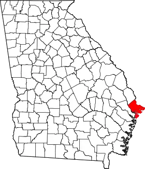
Thunderbolt, Georgia | |
|---|---|
 Location in Chatham County and the state of Georgia | |
| Coordinates: 32°1′56″N 81°3′6″W / 32.03222°N 81.05167°W | |
| Country | United States |
| State | Georgia |
| County | Chatham |
| Area | |
| • Total | 1.56 sq mi (4.04 km2) |
| • Land | 1.34 sq mi (3.48 km2) |
| • Water | 0.22 sq mi (0.56 km2) |
| Elevation | 20 ft (6 m) |
| Population (2020) | |
| • Total | 2,556 |
| • Density | 1,903.20/sq mi (734.87/km2) |
| Time zone | UTC-5 (Eastern (EST)) |
| • Summer (DST) | UTC-4 (EDT) |
| ZIP codes | 31404, 31410 |
| Area code | 912 |
| FIPS code | 13-76364[3] |
| GNIS feature ID | 0333226[2] |
| Website | www |
Thunderbolt is a town located in Chatham County, Georgia, United States, approximately five miles southeast of downtown Savannah. As of the 2020 census, the town had a total population of 2,556. It is part of the Savannah Metropolitan Statistical Area. Thunderbolt runs along the western shore of the Wilmington River (a tidal river that is part of the U.S. Intracoastal Waterway). The town is important to Georgia's shrimping industry, with scores of docks for shrimping trawlers. The town's picturesque atmosphere and seafood restaurants draw many local visitors.
History
An early variant name was "Warsaw". The Georgia General Assembly incorporated the town as "Warsaw" in 1856.[4] An act of legislature officially changed the town's name to "Thunderbolt" in 1921.[5]
According to tradition, Thunderbolt was named from an incident when lightning strike caused a spring to open up.[6]
Geography
Thunderbolt is located at 32°1'56" North, 81°3'6" West (32.032111, -81.051733).[7]
According to the United States Census Bureau, the town has a total area of 1.5 square miles (3.8 km2), of which 1.3 square miles (3.3 km2) is land and 0.2 square mile (0.5 km2) is water.
Demographics
| Census | Pop. | Note | %± |
|---|---|---|---|
| 1910 | 543 | — | |
| 1920 | 721 | 32.8% | |
| 1930 | 802 | 11.2% | |
| 1940 | 886 | 10.5% | |
| 1950 | 1,238 | 39.7% | |
| 1960 | 1,925 | 55.5% | |
| 1970 | 2,750 | 42.9% | |
| 1980 | 2,165 | −21.3% | |
| 1990 | 2,786 | 28.7% | |
| 2000 | 2,340 | −16.0% | |
| 2010 | 2,668 | 14.0% | |
| 2020 | 2,556 | −4.2% | |
| U.S. Decennial Census[8] | |||
| Race | Num. | Perc. |
|---|---|---|
| White (non-Hispanic) | 1,376 | 53.83% |
| Black or African American (non-Hispanic) | 639 | 25.0% |
| Native American | 1 | 0.04% |
| Asian | 81 | 3.17% |
| Other/Mixed | 115 | 4.5% |
| Hispanic or Latino | 344 | 13.46% |
As of the 2020 United States census, there were 2,556 people, 1,091 households, and 516 families residing in the town.
See also
- Samuel Bowen, who grew the first soya beans introduced to North America in Thunderbolt.
References
- ↑ "2020 U.S. Gazetteer Files". United States Census Bureau. Retrieved December 18, 2021.
- 1 2 U.S. Geological Survey Geographic Names Information System: Thunderbolt, Georgia
- ↑ "U.S. Census website". United States Census Bureau. Retrieved January 31, 2008.
- ↑ Krakow, Kenneth K. (1975). Georgia Place-Names: Their History and Origins (PDF). Macon, GA: Winship Press. p. 226. ISBN 0-915430-00-2.
- ↑ Acts and Resolutions of the General Assembly. 1921. p. 1122.
- ↑ Candler, Allen Daniel; Evans, Clement Anselm (1906). Georgia: Comprising Sketches of Counties, Towns, Events, Institutions, and Persons. State historical association. p. 443.
- ↑ "US Gazetteer files: 2010, 2000, and 1990". United States Census Bureau. February 12, 2011. Retrieved April 23, 2011.
- ↑ "Census of Population and Housing". Census.gov. Retrieved June 4, 2015.
- ↑ "Explore Census Data". data.census.gov. Retrieved December 14, 2021.
