Tiefenbach bei Kaindorf | |
|---|---|
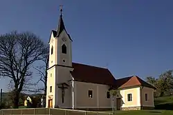 Obertiefenbach chapel | |
 Coat of arms | |
 Tiefenbach bei Kaindorf Location within Austria | |
| Coordinates: 47°13′17″N 15°51′32″E / 47.22139°N 15.85889°E | |
| Country | Austria |
| State | Styria |
| District | Hartberg-Fürstenfeld |
| Government | |
| • Mayor | Josef Singer (ÖVP) |
| Area | |
| • Total | 8.39 km2 (3.24 sq mi) |
| Elevation | 371 m (1,217 ft) |
| Population (1 January 2016)[1] | |
| • Total | 690 |
| • Density | 82/km2 (210/sq mi) |
| Time zone | UTC+1 (CET) |
| • Summer (DST) | UTC+2 (CEST) |
| Postal code | 8224 |
| Area code | 03334 |
| Vehicle registration | HB |
| Website | www.tiefenbach-kaindorf.steiermark.at |
Tiefenbach bei Kaindorf is a former municipality in the district of Hartberg-Fürstenfeld in Styria, Austria. Since the 2015 Styria municipal structural reform, it is part of the municipality Hartl.[2]
References
This article is issued from Wikipedia. The text is licensed under Creative Commons - Attribution - Sharealike. Additional terms may apply for the media files.