| Togwotee Pass | |
|---|---|
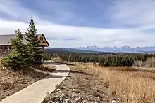
 Togwotee Pass from north, from Breccia Peak, Two Oceans Mountain on the right | |
| Elevation | 9,658 ft (2,944 m) |
| Traversed by | |
| Location | Teton County, Wyoming, U.S. |
| Range | Absaroka Range |
| Coordinates | 43°45′00″N 110°04′48″W / 43.75000°N 110.08000°W |
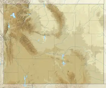
 Location in the United States  Location in Wyoming | |
Togwotee Pass (pronounced TOH-guh-tee)[1] is a high mountain pass in the western United States, at an elevation of 9,655 feet (2,943 m) above sea level. On the Continental Divide in the Absaroka Mountains of northwestern Wyoming in Teton County, it is between Dubois and Moran Junction in the Jackson Hole valley.[2]
U.S. Highways 287 and 26 traverse the pass, which is approximately 25 miles (40 km) east of Moran Junction. The pass provides the most direct access to Grand Teton National Park from eastern Wyoming. Located between Two Ocean Mountain[3] and Breccia Peak,[4] sweeping vistas of the Teton Range are visible from the western slopes of the pass. A ski run (mainly a traverse) at the Jackson Hole ski resort is also named Togwotee Pass.

Located in the Bridger-Teton National Forest and adjacent to Shoshone National Forest, the pass receives heavy winter snowfall and is a top destination for snowmobiling, backcountry skiing and cross-country skiing. Annual snowfall at the pass often exceeds 25 feet (7.6 m) (reports of over fifty feet (15 m) of snow are also known) in any given winter and the road can be shut down for days at a time during blizzards. The Continental Divide Snowmobile Trail passes through the immediate area.
History
The pass is named for Togwotee, a subchief under Chief Washakie of the Sheepeater tribe, a branch of the Shoshones. Togwotee led The Jones Expedition over this pass in 1873.[5][6] Before the expedition, the pass was reported to be an important trade route for native tribes.[7]
Climate
According to the Köppen Climate Classification system, Togwotee Pass has a dry-summer subarctic climate, abbreviated "Dsc" on climate maps. The hottest temperature recorded at Togwotee Pass was 81 °F (27.2 °C) on June 24, 1988 and July 13, 2002, while the coldest temperature recorded was −39 °F (−39.4 °C) on December 23, 1983.[8]
| Climate data for Togwotee Pass, Wyoming, 1991–2020 normals, extremes 1981–present | |||||||||||||
|---|---|---|---|---|---|---|---|---|---|---|---|---|---|
| Month | Jan | Feb | Mar | Apr | May | Jun | Jul | Aug | Sep | Oct | Nov | Dec | Year |
| Record high °F (°C) | 53 (12) |
50 (10) |
57 (14) |
66 (19) |
72 (22) |
81 (27) |
81 (27) |
79 (26) |
76 (24) |
67 (19) |
56 (13) |
46 (8) |
81 (27) |
| Mean maximum °F (°C) | 39.4 (4.1) |
39.8 (4.3) |
47.4 (8.6) |
55.9 (13.3) |
63.4 (17.4) |
70.7 (21.5) |
74.8 (23.8) |
73.5 (23.1) |
68.1 (20.1) |
58.6 (14.8) |
46.6 (8.1) |
37.8 (3.2) |
75.5 (24.2) |
| Mean daily maximum °F (°C) | 24.0 (−4.4) |
25.9 (−3.4) |
33.5 (0.8) |
39.8 (4.3) |
49.0 (9.4) |
57.4 (14.1) |
66.1 (18.9) |
64.7 (18.2) |
55.0 (12.8) |
41.8 (5.4) |
29.9 (−1.2) |
22.7 (−5.2) |
42.5 (5.8) |
| Daily mean °F (°C) | 16.3 (−8.7) |
17.0 (−8.3) |
23.4 (−4.8) |
29.0 (−1.7) |
38.1 (3.4) |
45.9 (7.7) |
54.0 (12.2) |
52.9 (11.6) |
44.6 (7.0) |
32.9 (0.5) |
21.9 (−5.6) |
15.3 (−9.3) |
32.6 (0.3) |
| Mean daily minimum °F (°C) | 8.6 (−13.0) |
8.1 (−13.3) |
13.2 (−10.4) |
18.1 (−7.7) |
27.1 (−2.7) |
34.4 (1.3) |
41.9 (5.5) |
41.0 (5.0) |
34.1 (1.2) |
24.0 (−4.4) |
13.9 (−10.1) |
7.8 (−13.4) |
22.7 (−5.2) |
| Mean minimum °F (°C) | −10.8 (−23.8) |
−10.5 (−23.6) |
−4.3 (−20.2) |
2.3 (−16.5) |
12.0 (−11.1) |
23.9 (−4.5) |
33.7 (0.9) |
31.8 (−0.1) |
20.8 (−6.2) |
6.1 (−14.4) |
−5.0 (−20.6) |
−11.9 (−24.4) |
−18.6 (−28.1) |
| Record low °F (°C) | −33 (−36) |
−33 (−36) |
−23 (−31) |
−19 (−28) |
−10 (−23) |
11 (−12) |
13 (−11) |
12 (−11) |
0 (−18) |
−16 (−27) |
−22 (−30) |
−39 (−39) |
−39 (−39) |
| Average precipitation inches (mm) | 4.39 (112) |
4.07 (103) |
4.02 (102) |
4.20 (107) |
3.54 (90) |
2.42 (61) |
1.32 (34) |
1.29 (33) |
2.32 (59) |
3.09 (78) |
4.34 (110) |
4.55 (116) |
39.55 (1,005) |
| Average extreme snow depth inches (cm) | 62.2 (158) |
73.7 (187) |
81.2 (206) |
83.0 (211) |
74.2 (188) |
43.0 (109) |
4.4 (11) |
0.0 (0.0) |
2.5 (6.4) |
14.4 (37) |
32.7 (83) |
49.6 (126) |
85.9 (218) |
| Average precipitation days (≥ 0.01 in) | 16.9 | 16.0 | 17.4 | 17.6 | 13.9 | 8.7 | 5.9 | 6.3 | 8.6 | 12.4 | 16.2 | 16.5 | 156.4 |
| Source 1: NOAA[9] | |||||||||||||
| Source 2: National Weather Service[8] | |||||||||||||
References
- ↑ "History". Togwatee Mountain Lodge.
- ↑ "Togwotee Pass". Geographic Names Information System. United States Geological Survey, United States Department of the Interior. Retrieved 2018-11-07.
- ↑ "Two Oceans Mountain : Climbing, Hiking & Mountaineering : SummitPost". summitpost.org. Retrieved February 14, 2012.
- ↑ "Breccia Peak - Wyoming, United States". peakery.com. Retrieved February 14, 2012.
- ↑ Jones, William A. (1875). THE RECONNAISSANCE Of NORTHWESTERN WYOMING INCLUDING YELLOWSTONE NATIONAL PARK. U.S. Government Printing Office. p. 1. ISBN 0331948184.
- ↑ Sanborn, Margaret (1978). The Grand Tetons : the story of the men who tamed the western wilderness. New York : Putnam. p. 267. ISBN 0399120459.
- ↑ Sanborn, Margaret (1978). The Grand Tetons : the story of the men who tamed the western wilderness. New York : Putnam. p. 38. ISBN 0399120459.
- 1 2 "NOAA Online Weather Data – NWS Riverton". National Weather Service. Retrieved December 11, 2022.
- ↑ "U.S. Climate Normals Quick Access – Station: Togwotee Pass, WY". National Oceanic and Atmospheric Administration. Retrieved December 11, 2022.