| Tongo Hills | |
|---|---|
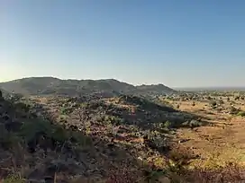
 View into the valley of the Tongo Hills | |
| Highest point | |
| Elevation | 355 m (1,165 ft) |
| Coordinates | 10°40′N 0°48′W / 10.667°N 0.800°W |
| Dimensions | |
| Length | 6 km (3.7 mi) |
| Area | 15.8 km2 (6.1 sq mi) |
| Geography | |
| Country | Ghana |
| Region | Upper East Region |
The Tongo Hills is a group of mountains located south of Tongo, Ghana. The hills are located in the Ghanaian Northern Plains.[1][2][3] The Hills form a U-shaped valley which is opened towards north. The community of Tenzug has seated at the end of this valley.
Additionally to the hills themselves there also are some other sights located next to Tenzug. These are:
- the Tenzug-Shrine. If you want to enter into this shrine you traditionally have to remove your shirt.
- the Old School which is a formation of rocks that used to be the school in the community
- the Hiding Cave where the inhabitants of Tenzug were hiding from the British colonialists
References
Wikimedia Commons has media related to Tongo Hills.
- ↑ News, A1 Radio (November 1, 2017). "Climbing the beautiful Tongo hills to the Mysterious Tengzuk Shrine".
{{cite web}}:|last=has generic name (help)CS1 maint: numeric names: authors list (link) - ↑ "Tengzug Tongo Hills and Shrines".
- ↑ "Ghana Museums & Monuments Board". www.ghanamuseums.org. Retrieved 2020-01-05.
This article is issued from Wikipedia. The text is licensed under Creative Commons - Attribution - Sharealike. Additional terms may apply for the media files.