| Straßenbahn Braunschweig | |||||||||||||||||||||
|---|---|---|---|---|---|---|---|---|---|---|---|---|---|---|---|---|---|---|---|---|---|
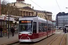
 An Alstom NGT8D tram in the Bohlweg, 2009. | |||||||||||||||||||||
| Operation | |||||||||||||||||||||
| Locale | Braunschweig, Lower Saxony, Germany | ||||||||||||||||||||
| |||||||||||||||||||||
| |||||||||||||||||||||
The Braunschweig tramway network (German: Straßenbahnnetz Braunschweig) is a network of tramways forming part of the public transport system in Braunschweig, a city in the federal state of Lower Saxony, Germany.
Opened in 1879, the network has been operated since its inception by the company now known as Braunschweiger Verkehrs-AG, and is integrated in the Verkehrsverbund Region Braunschweig (VRB).
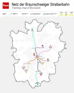
| Line | Termini | Route | Notes |
|---|---|---|---|
| 1 | Stöckheim – Wenden | Stöckheim – Melverode – (Heidberg) – Hauptbahnhof – Rathaus – Hamburger Straße – Stadion – Rühme - Wenden | |
| 2 | Heidberg – Siegfriedviertel | Heidberg – Hauptbahnhof/Leisewitzstraße – Rathaus – Hamburger Straße – Siegfriedviertel | During rush hour via Leisewitzstraße; in the evenings and on Sundays and holidays via Hauptbahnhof. |
| 3 | Weststadt Weserstraße – Volkmarode | Weststadt Weserstraße – Donauknoten – Cyriaksring – Europaplatz – Friedrich-Wilhelm-Straße – Rathaus – Hagenmarkt - Gliesmarode - Volkmarode | |
| 4 | Helmstedter Straße – Radeklint | Helmstedter Straße – Am Magnitor – Rathaus – Radeklint | |
| 5 | Broitzem – Hauptbahnhof | Broitzem – Weststadt Donauknoten – Cyriaksring – Europaplatz – Friedrich-Wilhelm-Straße – Schloss – Am Magnitor – Hauptbahnhof | |
| 10 | Hauptbahnhof - Rühme | Hauptbahnhof – Rathaus – Hamburger Straße – Stadion – Rühme | Monday - Friday between approximately 06:00 and 19:00 |
These lines originally had the letter M before the number, however this was stopped.
See also
References
- Höltge, Dieter (1992). Straßen- und Stadtbahnen in Deutschland [Tramways and Stadtbahnen in Germany] (in German). Vol. Band 2: Niedersachsen/Bremen [Volume 2: Lower Saxony/Bremen] (2nd ed.). Freiburg i. B., Germany: EK-Verlag. ISBN 3882553367.
- Höltge, Dieter (2004). Die Braunschweiger Straßenbahn: Personen-Nahverkehr in Braunschweig [The Braunschweiger Tramway: Local Passenger Transport in Braunschweig] (in German) (2nd ed.). München: GeraMond-Verlag. ISBN 376547195X.
External links
 Media related to Trams in Braunschweig at Wikimedia Commons
- Track plan of the Braunschweig tram system
- Braunschweig database / photo gallery and Braunschweig tram list at Urban Electric Transit – in various languages, including English.
- Braunschweig database / photo gallery at Phototrans – in various languages, including English.
This article is issued from Wikipedia. The text is licensed under Creative Commons - Attribution - Sharealike. Additional terms may apply for the media files.


