Trautmannsdorf in Oststeiermark | |
|---|---|
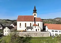 Trautmannsdorf parish church | |
 Coat of arms | |
 Trautmannsdorf in Oststeiermark Location within Austria | |
| Coordinates: 46°52′00″N 15°53′00″E / 46.86667°N 15.88333°E | |
| Country | Austria |
| State | Styria |
| District | Südoststeiermark |
| Government | |
| • Mayor | Christian Url (SPÖ) |
| Area | |
| • Total | 7.29 km2 (2.81 sq mi) |
| Elevation | 326 m (1,070 ft) |
| Population (1 January 2016)[1] | |
| • Total | 859 |
| • Density | 120/km2 (310/sq mi) |
| Time zone | UTC+1 (CET) |
| • Summer (DST) | UTC+2 (CEST) |
| Postal code | 8343, 8344 |
| Area code | +43 3159 |
| Vehicle registration | FB |
| Website | www.trautmannsdorf-st.at |
Trautmannsdorf in Oststeiermark is a former municipality with 859 inhabitants (1 January 2016) in the district of Südoststeiermark in the Austrian state of Styria. Since 1 January 2015 Trautmannsdorf is part of a new municipality with Bad Gleichenberg, Bairisch Kölldorf and Merkendorf. The new municipality is called Bad Gleichenberg.[2]
Population
| Year | Pop. | ±% |
|---|---|---|
| 1869 | 735 | — |
| 1880 | 814 | +10.7% |
| 1890 | 864 | +6.1% |
| 1900 | 804 | −6.9% |
| 1910 | 774 | −3.7% |
| 1923 | 780 | +0.8% |
| 1934 | 783 | +0.4% |
| 1939 | 747 | −4.6% |
| 1951 | 721 | −3.5% |
| 1961 | 769 | +6.7% |
| 1971 | 850 | +10.5% |
| 1981 | 878 | +3.3% |
| 1991 | 857 | −2.4% |
| 2001 | 877 | +2.3% |
| 2013 | 862 | −1.7% |
References
- ↑ Statistik Austria - Bevölkerung zu Jahresbeginn 2002-2016 nach Gemeinden (Gebietsstand 1.1.2016) for Trautmannsdorf in Oststeiermark.
- ↑ Die neue Gemeindestruktur der Steiermark
This article is issued from Wikipedia. The text is licensed under Creative Commons - Attribution - Sharealike. Additional terms may apply for the media files.