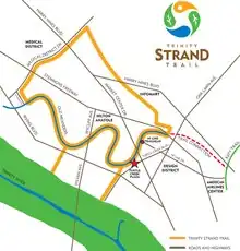
The Trinity Strand Trail is a partially completed 7.8-mile-long (12.6 km), hike/bike commuter and recreational trail that would run along the course of the original Trinity River in Dallas, Texas near the Dallas Design District. The trail is intended to connect the Dallas medical district with the Katy Trail and the Trinity River Corridor.[1][2][3]
As of 2011, the project had received approximately US$8 million from the city of Dallas bonds and the North Central Texas Council of Governments combined.[1] Trail construction began in 2010[4] and a 2.5-mile-long (4.0 km) segment was finished in 2014 at a cost of $5.4 million.[3]
The trail is supported by a non-profit organization Friends of the Trinity Strand Trail, formed in 2002.[1] The non-profit is partnered with another local non-profit, Friends of the Katy Trail, to connect the trail with Katy Trail. A land donation valued at $2 million was secured for the connection in 2007.[5][6]
References
Sources
- Joyce, Matt (July 1, 2011). "Dallas rolling toward Trinity trail". Dallas Business Journal.
- Joyce, Matt (March 15, 2012). "Trinity Strand trail work in Dallas inching forward". Dallas Business Journal.
- Nicholson, Eric (October 10, 2014). "Dallas' Trinity Strand Trail Is "Finished"". Dallas Observer. Retrieved 5 November 2023.
- Thompson, Steve (May 27, 2010). "Work starts on new Trinity Strand Trail in Dallas' Design District". The Dallas Morning News. Archived from the original on 5 August 2011.
- Wilonsky, Robert (October 30, 2007). "Happy (Katy and Trinity Strand) Trails". Dallas Observer.
- Wilonsky, Robert (May 10, 2012). "Take a ride on The Connection that will one day link the Katy Trail to the Trinity Strand Trail. At least, that's still the plan". The Dallas Morning News. Archived from the original on May 10, 2012. Retrieved May 11, 2012.