Troianata
Τρωιανάτα | |
|---|---|
 Troianata | |
| Coordinates: 38°9.5′N 20°33.4′E / 38.1583°N 20.5567°E | |
| Country | Greece |
| Administrative region | Ionian Islands |
| Regional unit | Kefalonia |
| Municipality | Argostoli |
| Municipal unit | Argostoli |
| Population (2011)[1] | |
| • Rural | 98 |
| Community | |
| • Population | 223 (2011) |
| Time zone | UTC+2 (EET) |
| • Summer (DST) | UTC+3 (EEST) |
| Vehicle registration | KE |
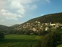
Troianata village in 2013
Troianata (Greek: Τρωιανάτα) is a village and a community in the municipal unit of Argostoli, on the island of Cephalonia, Greece. The community consists of the villages Troianata (population 98 in 2011), Demoutsantata (pop. 109) and Mitakata (pop. 16). Troianata is situated on a hillside, at about 300 m elevation. It is 3 km north of Peratata, 3 km southwest of Valsamata and 6 km southeast of Argostoli. Troianata suffered great damage from the 1953 Ionian earthquake.
Historical population
| Year | Population community |
|---|---|
| 1981 | 168 |
| 1991 | 130 |
| 2001 | 175 |
| 2011 | 223 |
See also
References
- 1 2 "Απογραφή Πληθυσμού - Κατοικιών 2011. ΜΟΝΙΜΟΣ Πληθυσμός" (in Greek). Hellenic Statistical Authority.
This article is issued from Wikipedia. The text is licensed under Creative Commons - Attribution - Sharealike. Additional terms may apply for the media files.