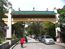
Archway of Tsok Pok Hang Village in February 2008.
.jpg.webp)
Distant view of Tsok Pok Hang San Tsuen on the hill slope, with Shui Chuen O Estate under construction in the background. The block on the left in the foreground is part of Pok Hong Estate.
Tsok Pok Hang Village (Chinese: 作壆坑村), also referred to as Tsok Pok Hang San Tsuen (作壆坑新村; 'Tsok Pok Hang New Village') or Tsok Pok Hang Resite Area, is a village in Sha Tin District, Hong Kong.
Administration
Tsok Pok Hang Resite Area is a recognized village under the New Territories Small House Policy.[1] For electoral purposes, Tsok Pok Hang San Tsuen is part of the Jat Chuen constituency.
History
Tsok Pok Hang was previously named Sok Pok Hang (塑壆坑; 'Mud Bund Stream').[2]
See also
References
- ↑ "List of Recognized Villages under the New Territories Small House Policy" (PDF). Lands Department. September 2009.
- ↑ Hase, P. H. (2020). Settlement, Life, and Politics - Understanding the Traditional New Territories. Royal Asiatic Society Hong Kong studies series. City University of Hong Kong Press. p. 277. ISBN 9789629374419.
External links
Wikimedia Commons has media related to Tsok Pok Hang Village.
22°22′24″N 114°11′41″E / 22.37332°N 114.19464°E
This article is issued from Wikipedia. The text is licensed under Creative Commons - Attribution - Sharealike. Additional terms may apply for the media files.