Tuapa | |
|---|---|
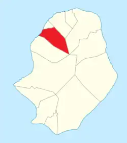 Tuapa council within Niue | |
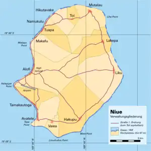 Administrative map of Niue showing all the villages | |
| Coordinates: 18°57′S 169°54′W / 18.950°S 169.900°W | |
| Country | |
| Tribal Area | Motu |
| Area | |
| • Total | 12.54 km2 (4.84 sq mi) |
| Population (2017)[1] | |
| • Total | 112 |
| • Density | 7.74/km2 (20.0/sq mi) |
| Time zone | UTC-11 (UTC-11) |
| Area code | +683 |
Tuapa is one of the fourteen villages of Niue.[2] Its population at the 2017 census was 112, up from 97 in 2011.[3]
Villagers from Tuapa established the villages of Makefu, Hikutavake, and Namukulu.[4]
References
- ↑ "Niue Household and Population Census 2017" (PDF). niue.prism.spc.int. Niue Statistics Office. Retrieved 5 May 2020.
- ↑ 1558548 Tuapa on OpenStreetMap
- ↑ "Niue Household and Population Census 2017" (PDF). niue.prism.spc.int. Niue Statistics Office. Retrieved 5 May 2020.
- ↑ "Namukulu celebrates in style its 100th anniversary". TV Niue. Retrieved 3 December 2022.
This article is issued from Wikipedia. The text is licensed under Creative Commons - Attribution - Sharealike. Additional terms may apply for the media files.