Tufara | |
|---|---|
| Comune di Tufara | |
 | |
Location of Tufara | |
 Tufara Location of Tufara in Italy 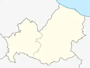 Tufara Tufara (Molise) | |
| Coordinates: 41°29′N 14°57′E / 41.483°N 14.950°E | |
| Country | Italy |
| Region | Molise |
| Province | Campobasso (CB) |
| Government | |
| • Mayor | Donato Pozzuto |
| Area | |
| • Total | 35.52 km2 (13.71 sq mi) |
| Elevation | 420 m (1,380 ft) |
| Population (31 December 2017)[2] | |
| • Total | 887 |
| • Density | 25/km2 (65/sq mi) |
| Demonym | Tufaroli |
| Time zone | UTC+1 (CET) |
| • Summer (DST) | UTC+2 (CEST) |
| Postal code | 86010 |
| Dialing code | 0874 |
| Patron saint | John of Tufara |
| Saint day | August 28 |
| Website | Official website |
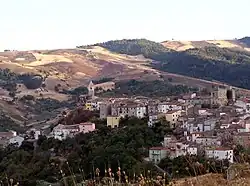
Tufara is a comune (municipality) in the Province of Campobasso in the Italian region Molise, located about 25 kilometres (16 mi) southeast of Campobasso.
Tufara borders the following municipalities: Castelvetere in Val Fortore, Celenza Valfortore, Gambatesa, Riccia, San Bartolomeo in Galdo, San Marco la Catola.
References
- ↑ "Superficie di Comuni Province e Regioni italiane al 9 ottobre 2011". Italian National Institute of Statistics. Retrieved 16 March 2019.
- ↑ All demographics and other statistics: Italian statistical institute Istat.
External links
![]() Media related to Tufara at Wikimedia Commons
Media related to Tufara at Wikimedia Commons
- Official website (in Italian)
This article is issued from Wikipedia. The text is licensed under Creative Commons - Attribution - Sharealike. Additional terms may apply for the media files.