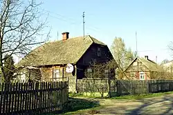
Turka | |
|---|---|
Village | |
 Turka in 2007 | |
 Turka | |
| Coordinates: 52°44′42″N 21°49′5″E / 52.74500°N 21.81806°E | |
| Country | |
| Voivodeship | Masovian |
| County | Ostrów |
| Gmina | Ostrów Mazowiecka |
| Time zone | UTC+1 (CET) |
| • Summer (DST) | UTC+2 (CEST) |
| Postal code | 07-300[1] |
| Vehicle registration | WOR |
Turka [ˈturka] is a village in the administrative district of Gmina Ostrów Mazowiecka, within Ostrów County, Masovian Voivodeship, in central Poland.[2]
History
| Year | Pop. | ±% |
|---|---|---|
| 1827 | 55 | — |
| 1921 | 100 | +81.8% |
| Source: [3][4] | ||
Turka was a private church village of the Diocese of Płock,[3] administratively located in the Masovian Voivodeship in the Greater Poland Province of the Kingdom of Poland. As a village adjacent to Nagoszewo, the inhabitants of Turka enjoyed the privileges of Nagoszewo.[3]
In 1921, the population was entirely Polish by nationality.[4]
Transport
The Expressway S8 passes nearby, north-west of the village.
References
- ↑ "Oficjalny Spis Pocztowych Numerów Adresowych" (PDF). Poczta Polska (in Polish). Retrieved 11 January 2024.
- ↑ Rozporządzenie Ministra Administracji i Cyfryzacji z dnia 13 grudnia 2012 r. w sprawie wykazu urzędowych nazw miejscowości i ich części, Dz. U. z 2013 r. poz. 200
- 1 2 3 Słownik geograficzny Królestwa Polskiego i innych krajów słowiańskich, Tom XII (in Polish). Warszawa. 1892. p. 639.
{{cite book}}: CS1 maint: location missing publisher (link) - 1 2 Skorowidz miejscowości Rzeczypospolitej Polskiej (in Polish). Vol. V. Warszawa: Główny Urząd Statystyczny. 1924. p. 66.
This article is issued from Wikipedia. The text is licensed under Creative Commons - Attribution - Sharealike. Additional terms may apply for the media files.