Twin Creeks, Montana | |
|---|---|
 Twin Creeks  Twin Creeks | |
| Coordinates: 46°54′45″N 113°42′49″W / 46.91250°N 113.71361°W | |
| Country | United States |
| State | Montana |
| County | Missoula |
| Area | |
| • Total | 1.12 sq mi (2.89 km2) |
| • Land | 1.12 sq mi (2.89 km2) |
| • Water | 0.00 sq mi (0.00 km2) |
| Elevation | 3,410 ft (1,040 m) |
| Population (2020) | |
| • Total | 164 |
| • Density | 146.69/sq mi (56.66/km2) |
| Time zone | UTC-7 (Mountain (MST)) |
| • Summer (DST) | UTC-6 (MDT) |
| ZIP Code | 59823 (Bonner) |
| Area code | 406 |
| FIPS code | 30-75550 |
| GNIS feature ID | 2806652[2] |
Twin Creeks is an unincorporated community and census-designated place (CDP) in Missoula County, Montana, United States. It is in the eastern part of the county, on the north side of the Blackfoot River. Montana Highway 200 passes through the community, leading northeast 35 miles (56 km) to Ovando and west 15 miles (24 km) to Missoula.
Twin Creeks was first listed as a CDP prior to the 2020 census.[2]
Demographics
| Census | Pop. | Note | %± |
|---|---|---|---|
| 2020 | 164 | — | |
| U.S. Decennial Census[3] | |||
References
- ↑ "ArcGIS REST Services Directory". United States Census Bureau. Retrieved September 5, 2022.
- 1 2 "Twin Creeks Census Designated Place". Geographic Names Information System. United States Geological Survey, United States Department of the Interior.
- ↑ "Census of Population and Housing". Census.gov. Retrieved June 4, 2016.
Municipalities and communities of Missoula County, Montana, United States | ||
|---|---|---|
| City | 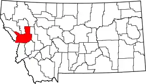 Missoula County map | |
| CDPs | ||
| Other communities | ||
| Ghost towns | ||
| Indian reservation | ||
| Footnotes | ‡This populated place also has portions in an adjacent county or counties | |
This article is issued from Wikipedia. The text is licensed under Creative Commons - Attribution - Sharealike. Additional terms may apply for the media files.