Ugwunagbo | |
|---|---|
LGA and town | |
 Ugwunagbo Location of Ugwunagbo in Nigeria | |
| Coordinates: 4°59′4.1053″N 7°19′32.82″E / 4.984473694°N 7.3257833°E | |
| Country | |
| State | Abia State |
| Area | |
| • Total | 42 sq mi (108 km2) |
| Population (2011) | |
| • Total | 97,710[1] |
| Time zone | UTC+1 (WAT) |
Ugwunagbo is a local government area of Abia State, Nigeria.
It has an area of 108 km2 and had a population of 97,710 at the 2011 census. It is a suburb of AbaEconomy
Ugwunagbo depends solely on farming. It supplies farm products like yam, maize, cocoa, and palm oil to Aba and environs. Ugwunagbo also have little deposit of crude oil which can be found in Obuzo. It also has substantial cities like Obegu, Ngwayiekwe, Ihie, and Asa-Umunka.[2]
Geography
The overall area of Ugwunagbo LGA is 108 square kilometers, and its average annual temperature is 26 degrees Celsius. The Local Government Area experiences two different seasons: the rainy season and the dry season. The average wind speed in the region is estimated to be 10 km/h.[3]
Town [4]
- Amaokpu-Umuitiri
- Abayi
- Alaoji
- Akanu
- Umugo
- Umule-Osoamadi
- Umunkama
- Umuod
- Ukebe
- Umuaja
- Umuama-Oke
- Obegu
- Obuzor
- Osusu-Aku
- Ozaa-Umuebukwu
- Umuchewu
- Asaomumakwa
- Ngwaiyiekwe
- Nngwa
- Amuzu-Amaikoro
- Asa-Amuhi
- Asa-Nnentu
- Asa-Oberie
- Asa-Umunka
- Amaorji
- Amapu-Ukebe
- Amapu-Umodo
Amavo
Agriculture
The residents of Ugwunagbo rely primarily on agriculture as their main source of sustenance. They provide crops like yam, maize, cocoa, and palm oil to Aba and the surrounding areas. The people of Ugwunagbo Local Government Area participate in a variety of economic endeavors to support their livelihoods. These pursuits encompass agriculture, trade, small-scale businesses, and some industrial activities. Agriculture is a pivotal component of the local economy, with the cultivation of crops like yam, cassava, oil palm, maize, and vegetables. Additionally, they engage in livestock farming, which includes poultry and pig rearing.[5]
The market
Ugwunagbo Central Market, situated in the administrative hub of Ugwunagbo Local Government Area, functions as the primary marketplace for the local inhabitants. It acts as a significant trading hub, providing a wide array of goods and merchandise. The market is renowned for its bustling trade operations and draws traders from different areas within the Local Government Area.[6]
References
- ↑ UGWUNAGBO (Local Government Area)
- ↑ "Ugwunagbo LGA". www.finelib.com. Retrieved 2023-08-04.
- ↑ "Ugwunagbo Local Government Area". www.manpower.com.ng. Retrieved 2023-08-04.
- ↑ places (1970-01-01). "Towns & Villages in Ugwunagbo « Abia State « Nigeria". Towns & Villages. Retrieved 2023-08-04.
- ↑ propertypro.ng. "Ugwunagbo | Neighbourhood Guide". Retrieved 2023-11-01.
- ↑ propertypro.ng. "Ugwunagbo | Neighbourhood Guide". Retrieved 2023-11-01.
Capital: Umuahia | ||
| Local government areas | 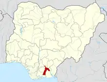 | |