Union Township | |
|---|---|
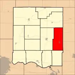 Location in Jefferson County | |
| Coordinates: 39°12′58″N 95°13′03″W / 39.21611°N 95.21750°W | |
| Country | United States |
| State | Kansas |
| County | Jefferson |
| Area | |
| • Total | 42.83 sq mi (110.92 km2) |
| • Land | 42.7 sq mi (110.59 km2) |
| • Water | 0.13 sq mi (0.33 km2) 0.3% |
| Elevation | 1,158 ft (353 m) |
| Population (2000) | |
| • Total | 1,672 |
| • Density | 39.2/sq mi (15.1/km2) |
| GNIS feature ID | 0478347 |
Union Township is a township in Jefferson County, Kansas, USA. As of the 2000 census, its population was 1,672.
Geography
Union Township covers an area of 42.83 square miles (110.92 square kilometers); of this, 0.13 square miles (0.33 square kilometers) or 0.3 percent is water. The stream of Scatter Creek runs through this township.
Cities and towns
Adjacent townships
- Jefferson Township (north)
- Alexandria Township, Leavenworth County (northeast)
- Tonganoxie Township, Leavenworth County (southeast)
- Sarcoxie Township (south)
- Oskaloosa Township (west)
Cemeteries
The township contains one cemetery, Fowler.
Major highways
Airports and landing strips
- Threshing Bee Airport
References
External links
Municipalities and communities of Jefferson County, Kansas, United States | ||
|---|---|---|
| Cities | 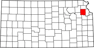 Map of Kansas highlighting Jefferson County | |
| Unincorporated communities | ||
| Townships | ||
| Footnotes | †This community is designated a Census-Designated Place (CDP) by the United States Census Bureau. | |
This article is issued from Wikipedia. The text is licensed under Creative Commons - Attribution - Sharealike. Additional terms may apply for the media files.