| Ussuri ᡠᠰᡠᡵᡳ ᡠᠯᠠ usuri ula (in Manchu) | |
|---|---|
 | |
| Location | |
| Country | China, Russia |
| Physical characteristics | |
| Mouth | Amur |
• coordinates | 48°16′00″N 134°43′13″E / 48.2666°N 134.7204°E |
| Length | 897 km (557 mi)[1] |
| Basin size | 193,000 km2 (75,000 sq mi) |
| Discharge | |
| • location | Khabarovsk, Russia (near mouth) |
| • average | 1,620 m3/s (57,000 cu ft/s)[1] |
| Basin features | |
| Progression | Amur→ Sea of Okhotsk |
| Ussuri | |||||||||||||
|---|---|---|---|---|---|---|---|---|---|---|---|---|---|
 | |||||||||||||
| Chinese name | |||||||||||||
| Traditional Chinese | 烏蘇里江 | ||||||||||||
| Simplified Chinese | 乌苏里江 | ||||||||||||
| |||||||||||||
| Manchu name | |||||||||||||
| Manchu script | ᡠᠰᡠᡵᡳ ᡠᠯᠠ | ||||||||||||
| Romanization | usuri ula | ||||||||||||
| Russian name | |||||||||||||
| Russian | река Уссури | ||||||||||||
| Romanization | reka Ussuri | ||||||||||||
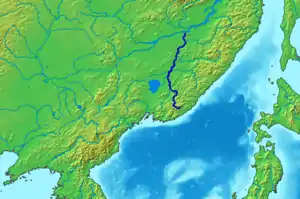
The Ussuri or Wusuli (Russian: Уссури; Chinese: 乌苏里江; pinyin: Wūsūlǐ Jiāng) is a river that runs through Khabarovsk and Primorsky Krais, Russia and the southeast region of Northeast China. It rises in the Sikhote-Alin mountain range, flowing north and forming part of the Sino-Russian border (which is based on the Sino-Russian Convention of Peking of 1860), until it joins the Amur as a tributary to it near Khabarovsk. It is approximately 897 km (557 mi) long. The Ussuri drains the Ussuri basin, which covers 193,000 km2 (75,000 sq mi).[2] Its waters come from rain (60%), snow (30–35%), and subterranean springs. The average discharge is 1,620 m3/s (57,000 cu ft/s),[1] and the average elevation is 1,682 metres (5,518 ft).
Names

The Ussuri has been known by many names. In Manchu, it was called the Usuri Ula or Dobi Bira (River of Foxes) and in Mongolian the Üssüri Müren.[3] Ussuri is Manchu for soot-black river.[4]
History
- The Ussuri has a reputation for catastrophic floods. It freezes up in November and stays under the ice until April. The river teems with different kinds of fish: grayling, sturgeon, humpback salmon (gorbusha), chum salmon (keta), and others.
- During World War II, the river marked one of the boundaries which Soviet forces crossed into Manchuria in Operation August Storm in 1945.
- The Sino-Soviet border conflict of 1969 took place at the Soviet Damansky Island on the Ussuri River.
Tributaries
Major tributaries of the Ussuri are, from source to mouth:
- Arsenyevka (left)
- Sungacha (left)
- Muling (left)
- Bolshaya Ussurka (right)
- Bikin (right)
- Naoli (left)
- Khor (right)
See also
References
- 1 2 3 Amur-Heilong River Basin Reader (PDF). ISBN 9789881722713.
- ↑ Уссури, Great Soviet Encyclopedia
- ↑ Narangoa 2014, p. 299.
- ↑ Shavkunov E.V., Professor, Doctor of Historical Sciences, Head of the Sector of Archeology of Medieval States of the Institute of History of the Far Eastern Military District. "Книги и статьи по топонимике". toponimika.ru (in Russian). Retrieved 2022-01-20.
{{cite web}}: CS1 maint: multiple names: authors list (link)
Sources
- Narangoa, Li (2014). Historical Atlas of Northeast Asia, 1590-2010: Korea, Manchuria, Mongolia, Eastern Siberia. New York: Columbia University Press. ISBN 9780231160704.
External links
- Article containing a detail map[dead link as of 18 March 2017]
- http://www.unu.edu/unupress/unupbooks/80349e/80349E10.GIF