| Ustye | |
|---|---|
 | |
| Native name | Устье (Russian) |
| Location | |
| Country | Russia |
| Physical characteristics | |
| Mouth | Kotorosl |
• coordinates | 57°14′43″N 39°31′12″E / 57.2454°N 39.5199°E |
| Length | 153 km (95 mi) |
| Basin size | 2,530 km2 (980 sq mi) |
| Basin features | |
| Progression | Kotorosl→ Volga→ Caspian Sea |
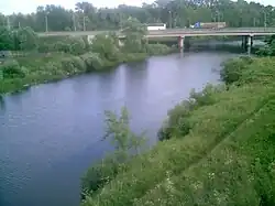
The Ustye (Russian: Устье) is a river in Yaroslavl Oblast in Russia, a left tributary of the river Kotorosl (Volga's basin).[1] The river is 153 kilometres (95 mi) long, and the area of its drainage basin is 2,530 square kilometres (980 sq mi).[2] The Ustye freezes up in November and breaks up in April.
References
- ↑ Устье (река в Ярославской обл.), Great Soviet Encyclopedia
- ↑ «Река Устье», Russian State Water Registry
This article is issued from Wikipedia. The text is licensed under Creative Commons - Attribution - Sharealike. Additional terms may apply for the media files.