Utena District Municipality
Utenos rajono savivaldybė | |
|---|---|
.svg.png.webp) Coat of arms | |
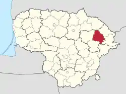 Location of Utena district municipality within Lithuania | |
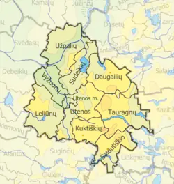 Map of Utena district municipality | |
| Country | |
| Ethnographic region | Aukštaitija |
| County | |
| Capital | Utena (town) |
| Elderships | 10 |
| Area | |
| • Total | 1,229 km2 (475 sq mi) |
| • Rank | 29th |
| Population (2021[1]) | |
| • Total | 37,509 |
| • Rank | 18-19th |
| • Density | 31/km2 (79/sq mi) |
| • Rank | 19th |
| Time zone | UTC+2 (EET) |
| • Summer (DST) | UTC+3 (EEST) |
| Telephone code | 389 |
| Major settlements | |
| Website | www |
Utena District Municipality is one of 60 municipalities in Lithuania.
Structure
District structure:
- 1 city – Utena;
- 8 towns – Daugailiai, Kuktiškės, Leliūnai, Saldutiškis, Sudeikiai, Tauragnai, Užpaliai and Vyžuonos;
- 592 villages.
Population of largest Molėtai District Municipality elderships (2001):
Nature and geography

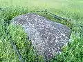 Puntukas of Biliakiemis
.jpg.webp) Indrajai
Indrajai
References
- ↑ "Gyventojai gyvenamosiose vietovėse (Residents in residential areas)". Archived from the original (XLSX) on 2022-09-30. Retrieved 2024-01-17.
| Municipalities |  | |
|---|---|---|
| Cities | ||
| Towns | ||
| Villages | ||
55°31′12″N 25°38′49″E / 55.52000°N 25.64694°E
This article is issued from Wikipedia. The text is licensed under Creative Commons - Attribution - Sharealike. Additional terms may apply for the media files.