| Valdivia River (Río Valdivia) | |
|---|---|
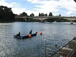
 View of the upper course of Valdivia River. Pedro de Valdivia Bridge is seen in the background. | |
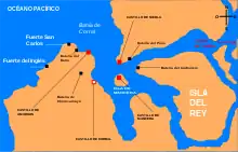
 Map of the mouth of the Valdivia | |
| Location | |
| Country | Chile |
| Physical characteristics | |
| Source | |
| • location | Calle-Calle River, Caucau River |
| Mouth | |
• location | Corral Bay, Pacific Ocean |
• coordinates | 39°52′37″S 73°22′56″W / 39.87694°S 73.38222°W |
• elevation | 0 m (0 ft) |
| Length | 15 km (9.3 mi)[1] |
| Basin size | 10,275 km2 (3,967 sq mi)[1] |
| Discharge | |
| • average | 687 m3/s (24,300 cu ft/s)[2] |
| Basin features | |
| Basin population | 168,489[1] |
The Valdivia River or Río Valdivia, as it is known locally, is a major river in southern Chile. It is the continuation of the Calle-Calle River, from the point where it meets the Cau-Cau River in the city of Valdivia. The Valdivia river ends in Corral Bay, on the Pacific coast. Other tributaries are the Cruces River, the Tornagaleones River and the Futa River. Pedro de Valdivia Bridge crosses the river in downtown Valdivia.
The foraminiferal fauna of the wetlands adjoining the river is dominated by Trochamminita salsa.[3]
References
- 1 2 3 "Cuenca del río Valdivia" (PDF). Archived from the original (PDF) on 2007-09-27. Retrieved 2007-10-28.
- ↑ "Hidrografía Región de los Ríos". Biblioteca del Congreso Nacional de Chile (in Spanish). Archived from the original on 2022-03-04. Retrieved 2022-03-02.
- ↑ Jenningst, Anne E.; Nelsont, Alan R.; Scott, David B.; Aravena, Juan Carlos (1995). "Marsh Foraminiferal Assemblages in the Valdivia Estuary, South-central Chile, Relative to Vascular Plants and Sea Level". Journal of Coastal Research. 11 (1): 107–123.
External links
This article is issued from Wikipedia. The text is licensed under Creative Commons - Attribution - Sharealike. Additional terms may apply for the media files.