Valmont, Colorado | |
|---|---|
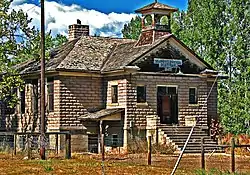 Valmont School, built in 1911 (2010 photo) | |
 Location of the Valmont CDP in Boulder County, Colorado. | |
 Valmont Location of the Valmont CDP in the United States. | |
| Coordinates: 40°02′03″N 105°12′21″W / 40.0341647°N 105.2058503°W[1] | |
| Country | |
| State | |
| County | Boulder County |
| Platted | 1865 |
| Government | |
| • Type | unincorporated community |
| Area | |
| • Total | 0.352 sq mi (0.912 km2) |
| • Land | 0.269 sq mi (0.698 km2) |
| • Water | 0.083 sq mi (0.214 km2) |
| Population | |
| • Total | 64 |
| • Density | 180/sq mi (70/km2) |
| Time zone | UTC-7 (MST) |
| • Summer (DST) | UTC-6 (MDT) |
| ZIP Code[4] | Boulder 80301 |
| Area codes | 303 & 720 |
| GNIS feature[2] | Valmont CDP |
Valmont is an unincorporated community and a census-designated place (CDP) located in and governed by Boulder County, Colorado, United States. The CDP is a part of the Boulder, CO Metropolitan Statistical Area. The population of the Valmont CDP was 64 at the United States Census 2020.[3] The Boulder post office (Zip Code 80301) serves the area.[4]
History
Valmont was platted in 1865, and named for the valleys and peaks near the town site.[5] A post office called Valmont was established in 1865, and remained in operation until 1901.[6]
Valmont Station
The Valmont train depot is an abandoned station stop for the Union Pacific Railroad's Boulder Branch from Denver to Boulder, Colorado. It was originally built in 1890 to serve as a depot for the railroad's service on the Boulder Branch at milepost 24.[7] Train numbers 515 and 516, the designated train numbers for the branch line, usually served this branch with the use of self-propelled railcars until the passenger service was discontinued in the 1960s.[8]
Geography
Valmont is located in southeastern Boulder County, east of the city of Boulder, between Boulder Creek to the north and 200-foot-tall (60 m) Valmont Butte to the south. Valmont Road runs through the center of the community.
The Valmont CDP has an area of 225 acres (0.912 km2), including 53 acres (0.214 km2) of water.[1]
Demographics
The United States Census Bureau initially defined the Valmont CDP for the United States Census 2010.
| Year | Pop. | ±% |
|---|---|---|
| 2010 | 59 | — |
| 2020 | 64 | +8.5% |
| Source: United States Census Bureau | ||
See also
References
- 1 2 3 "State of Colorado Census Designated Places - BAS20 - Data as of January 1, 2020". United States Census Bureau. Retrieved December 12, 2020.
- 1 2 "U.S. Board on Geographic Names: Domestic Names". United States Geological Survey. Retrieved December 12, 2020.
- 1 2 United States Census Bureau. "Valmont CDP, Colorado". Retrieved April 17, 2023.
- 1 2 "Zip Code 80301 Map and Profile". zipdatamaps.com. 2020. Retrieved December 20, 2020.
- ↑ Dawson, John Frank. Place names in Colorado: why 700 communities were so named, 150 of Spanish or Indian origin. Denver, CO: The J. Frank Dawson Publishing Co. p. 50.
- ↑ "Post offices". Jim Forte Postal History. Retrieved July 11, 2016.
- ↑ "Brighton to St. Vrains, CO - Abandoned Rails". www.abandonedrails.com. Retrieved July 16, 2020.
- ↑ "Union Pacific Railroad" (PDF). September 16, 1937.
External links
Municipalities and communities of Boulder County, Colorado, United States | ||
|---|---|---|
| Cities |  Map of Colorado highlighting Boulder County | |
| Towns | ||
| CDPs | ||
| Unincorporated communities | ||
| Ghost town | ||
| Footnotes | ‡This populated place also has portions in an adjacent county or counties | |