Veľké Pole | |
|---|---|
Village | |
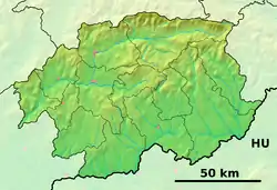 Veľké Pole Location of Veľké Pole in the Banská Bystrica Region  Veľké Pole Veľké Pole (Slovakia) | |
| Coordinates: 48°32′26″N 18°33′54″E / 48.54056°N 18.56500°E | |
| Country | Slovakia |
| Region | Banská Bystrica |
| District | Žarnovica |
| First mentioned | 14th century |
| Area | |
| • Total | 35.61[1] km2 (13.75[1] sq mi) |
| Elevation | 522[2] m (1,713[2] ft) |
| Population (2021) | |
| • Total | 411[3] |
| Time zone | UTC+1 (CET) |
| • Summer (DST) | UTC+2 (CEST) |
| Area code | +421 45[2] |
Veľké Pole (German: Hochwies; Hungarian: Pálosnagymező) is a village and municipality in the Žarnovica District, Banská Bystrica Region in Slovakia.
History
Hochwies - a Carpathian Germans village in the Hauerland, from the 13th century to 1945, in the territory of today's Slovakia.[4]
References
- 1 2 "Hustota obyvateľstva - obce [om7014rr_ukaz: Rozloha (Štvorcový meter)]". www.statistics.sk (in Slovak). Statistical Office of the Slovak Republic. 2022-03-31. Retrieved 2022-03-31.
- 1 2 3 "Základná charakteristika". www.statistics.sk (in Slovak). Statistical Office of the Slovak Republic. 2015-04-17. Retrieved 2022-03-31.
- ↑ "Počet obyvateľov podľa pohlavia - obce (ročne)". www.statistics.sk (in Slovak). Statistical Office of the Slovak Republic. 2022-03-31. Retrieved 2022-03-31.
- ↑ "Google Maps". maps.google.com. Retrieved 3 August 2016.
External links
- https://web.archive.org/web/20070513023228/http://www.statistics.sk/mosmis/eng/run.html
- http://www.imm.hs-karlsruhe.de/slovakei/index.php?lang=eng
Municipalities of Žarnovica District | ||
|---|---|---|
This article is issued from Wikipedia. The text is licensed under Creative Commons - Attribution - Sharealike. Additional terms may apply for the media files.