Veľký Folkmár | |
|---|---|
Village | |
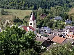 View on Veľký Folkmár | |
 Location of Gelnica District in the Košice Region | |
| Country | Slovakia |
| Region | Košice |
| District | Gelnica |
| First mentioned | 1336 |
| Area | |
| • Total | 23.10[1] km2 (8.92[1] sq mi) |
| Elevation | 379[2] m (1,243[2] ft) |
| Population (2021) | |
| • Total | 878[3] |
| Time zone | CET (UTC+1) |
| • Summer (DST) | CEST (UTC+2) |
| Postal code | 055 51[2] |
| Area code | +421 53[2] |
48°51′20″N 21°00′50″E / 48.855623°N 21.013927°E Veľký Folkmár (Hungarian: Nagysolymár) is a village and municipality in the Gelnica District in the Košice Region of eastern Slovakia.[4]
Geography
Veľký Folkmár is located in the area of Slovak Ore Mountains, further, it lies in a unit of Volovské Vrchy and Kojšovská Hoľa sub-whole. River Kojšovský potok flows through the village. Veľký Folkmár lies at an altitude of 370 meters above sea level. The village lies in a valley with hilly terrain and wooded areas around it. The highest peak of Veľký Folkmár is Folkmarská Skala with an altitude of 915 meters above sea level.
Veľký Folkmár is a part of the Košice Region, further, it is a part of the Gelnica district.
References
- 1 2 "Hustota obyvateľstva - obce [om7014rr_ukaz: Rozloha (Štvorcový meter)]". www.statistics.sk (in Slovak). Statistical Office of the Slovak Republic. 2022-03-31. Retrieved 2022-03-31.
- 1 2 3 4 "Základná charakteristika". www.statistics.sk (in Slovak). Statistical Office of the Slovak Republic. 2015-04-17. Retrieved 2022-03-31.
- ↑ "Počet obyvateľov podľa pohlavia - obce (ročne)". www.statistics.sk (in Slovak). Statistical Office of the Slovak Republic. 2022-03-31. Retrieved 2022-03-31.
- ↑ "Veľký Folkmár - Okres Gelnica - E-OBCE.sk".
External links
Wikimedia Commons has media related to Veľký Folkmar.
Municipalities of Gelnica District | ||
|---|---|---|
This article is issued from Wikipedia. The text is licensed under Creative Commons - Attribution - Sharealike. Additional terms may apply for the media files.