Vernon Township | |
|---|---|
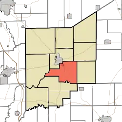 Location in Jennings County | |
| Coordinates: 38°57′17″N 85°35′55″W / 38.95472°N 85.59861°W | |
| Country | United States |
| State | Indiana |
| County | Jennings |
| Government | |
| • Type | Indiana township |
| Area | |
| • Total | 34.08 sq mi (88.3 km2) |
| • Land | 33.98 sq mi (88.0 km2) |
| • Water | 0.1 sq mi (0.3 km2) 0.29% |
| Elevation | 748 ft (228 m) |
| Population (2010) | |
| • Total | 2,809 |
| • Density | 82.7/sq mi (31.9/km2) |
| GNIS feature ID | 0453957 |
Vernon Township is one of eleven townships in Jennings County, Indiana, United States. As of the 2010 census, its population was 2,809 and it contained 1,118 housing units.[1]
Geography
According to the 2010 census, the township has a total area of 34.08 square miles (88.3 km2), of which 33.98 square miles (88.0 km2) (or 99.71%) is land and 0.1 square miles (0.26 km2) (or 0.29%) is water.[1] The streams of Crooked Creek, Duck Branch, Goose Run and Huckleberry Branch run through this township.
Cities and towns
- North Vernon (southeast edge)
- Vernon (the county seat)
Unincorporated towns
Adjacent townships
- Center Township (north)
- Campbell Township (northeast)
- Bigger Township (east)
- Lovett Township (southwest)
- Spencer Township (west)
Cemeteries
The township contains six cemeteries: Baldwin, Coryell, Ebenezer, Stewart, Sullivan and Vernon.
Major highways
References
- 1 2 "Population, Housing Units, Area, and Density: 2010 - County -- County Subdivision and Place -- 2010 Census Summary File 1". United States Census. Archived from the original on February 12, 2020. Retrieved May 10, 2013.
External links
Municipalities and communities of Jennings County, Indiana, United States | ||
|---|---|---|
| City | Map of Indiana highlighting Jennings County | |
| Town | ||
| Townships | ||
| CDPs | ||
| Other communities | ||
| Footnotes | ‡This populated place also has portions in an adjacent county or counties | |
This article is issued from Wikipedia. The text is licensed under Creative Commons - Attribution - Sharealike. Additional terms may apply for the media files.