Villa Crespo y San Andrés | |
|---|---|
Town | |
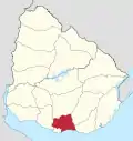
 Villa Crespo y San Andrés Location in Uruguay | |
| Coordinates: 34°44′0″S 56°6′0″W / 34.73333°S 56.10000°W | |
| Country | |
| Department | Canelones Department |
| Population (2011) | |
| • Total | 9,813 |
| Time zone | UTC -3 |
| Postal code | 91100 |
| Dial plan | +598 2 (+7 digits) |
Villa Crespo y San Andrés is a small town or populated centre in the Canelones Department of southern Uruguay. Together with its neighbouring Toledo, they form a population centre of about 13,800. They are both part of the wider metropitan area of Montevideo.
Geography
The town is located on Km. 22 of Route 6 and on Route 33, bordering Toledo to the east.
Population
In 2011 Villa Crespo y San Andrés had a population of 9,813.[1][2]
| Year | Population |
|---|---|
| 1975 | 4,786 |
| 1985 | 6,492 |
| 1996 | 8,107 |
| 2004 | 8,756 |
| 2011 | 9,813 |
Source: Instituto Nacional de Estadística de Uruguay[3]
References
- ↑ "Censos 2011 Cuadros Canelones". INE. 2012. Archived from the original on October 10, 2012. Retrieved 25 August 2012.
- ↑ "Censos 2011 Canelones". INE. 2012. Archived from the original on September 7, 2012. Retrieved 28 August 2012.
- ↑ "1963–1996 Statistics / V" (DOC). Instituto Nacional de Estadística de Uruguay. 2004. Retrieved 13 July 2011.
External links
Capital: Canelones | ||
| Towns and villages |
|  |
| Resorts of the Ciudad de la Costa | ||
| Sights |
| |
This article is issued from Wikipedia. The text is licensed under Creative Commons - Attribution - Sharealike. Additional terms may apply for the media files.