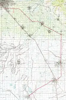
The Visalia District was a rail line in California's San Joaquin Valley that ran from Corcoran, California to Calwa, California. The line was originally built by the San Francisco and San Joaquin Valley Railroad and later acquired by the Atchison, Topeka and Santa Fe Railway.[1]
Construction and route
Construction began in 1897, with rails laid from Calwa to Visalia. Passenger service began on September 10, 1897. Subsequently, the line was extended from Visalia to Corcoran via Tulare, in 1898. Depots were established along the line every few miles. The route of the line including locations of significance was as follows:[1]
| Mile Post | Name | Notes |
|---|---|---|
| 0.00 | Corcoran | Originally called Jacobs Well |
| 0.30 | Corcoran Junction | Wye and connection with the Atchison, Topeka and Santa Fe Railway Valley Division. Yard Limits. |
| 4.40 | Waukena | Depot |
| 14.80 | Tulare Tower | Interlocking crossing with Southern Pacific Bakersfield Subdivision |
| 15.00 | Tulare | Depot and small 4-track yard. Yard Limits. |
| 20.20 | Loma | Location of agricultural products shipper; last remaining customer on line. Last rail shipment was around 2007. |
| 22.10 | Higby | 1000 ft spur, east connection |
| 23.70 - 24.00 (approx) | Ambler | SP/Santa Fe connecting track. Now called "Billy Goat Jct". Reconstructed by SJVR in 1992 to serve shipper at Loma. Was also used to service truck body manufacturer in Tulare until early 1994.[2] Out of service as of 2021. |
| 25.20 | Visalia | Depot and small 4-track yard. Siding length listed in 1984 timetable at 2338 ft. Yard Limits. |
| 25.30 | SP/VE crossing | In-street interlocking crossing with Visalia Electric Railroad |
| 33.30 | SP crossing | Interlocking crossing with Southern Pacific Exeter Branch |
| 36.20 | Calgro | Named for California Growers, who had a large winery on site. |
| 38.50 | Cutler | Depot and yard. Connection with the Santa Fe Porterville-Orosi District. Siding length listed in 1984 timetable at 3380 ft. Yard Limits. |
| 41.70 | Sultana | Depot |
| 43.90 | Enson | 270 ft spur, east connection |
| 48.90 | Reedley | Depot. Wye and connection with the Santa Fe Wahtoke District. Yard Limits. |
| 50.30 | SP crossing | Interlocking crossing with Southern Pacific Exeter Branch |
| 54.40 | Parlier | Depot, Siding length listed in 1984 timetable at 2651 ft. |
| 58.50 | Del Rey | Depot and small yard |
| 64.40 | Lone Star | Depot- last remaining intact depot on the line. Siding length listed in 1984 timetable at 1626 ft. |
| 65.20 | Mattei Spur | 2.2 mile spur, west connection |
| 68.90 | Calwa | Wye and connection with the Atchison, Topeka and Santa Fe Railway Valley Division. Yard Limits. |
General info
At the peak of passenger service around 1915, as many as 10 trains ran daily. In later years, service was provided by a doodlebug, sometimes pulling a trailer coach. Passenger service was eventually discontinued in 1949.[1]
Later Years
The line remained a valuable source of fright revenue for the Santa Fe through the 1970s, with produce being the predominant commodity. Many of the depots along the line were closed in the 1970s, but several remained open as of 1978, such as the depot in Cutler. Cutler was an important junction point on the line, with various lines extending north, south, and southwest. The other active depot on the line in 1978 was at Reedley. The Reedley depot was closed by 1979 and the one at Cutler was closed and demolished a few years later.[3]
TVRR ownership

On Dec 22, 1992, the line was sold to the Tulare Valley Railroad. The TVRR purchased the rail, ties, ballast, and land. The segment of the Visalia District between Corcoran and Tulare was not used by the TVRR, and the segment was removed by 1994, along with the SP crossing in Tulare. In addition, the segment between Visalia and Cutler was not used by the TVRR and was removed by Dec-1994, except for the SP connector track at the Early California Foods plant in south Visalia- milepost 23.70 - 24.00 (approx).[2]
A truck body manufacturer in Tulare was served by the TVRR until early 1994, when a vehicle transloading facility was built in Exeter. The segment from Loma to Tulare was subsequently abandoned and removed in late 1994.[2][4]
The TVRR itself became part of the San Joaquin Valley Railroad in 1998.
Along the line today
Corcoran to Tulare
A short segment of the line remains in Corcoran to serve on-line industries. The segment between Corcoran and Tulare was abandoned and removed by 1994.[2]
The right-of-way through Tulare was converted into a bike path, which was opened in 2004. Named the Santa Fe Trail, it is a 5 mile, lighted trail from Prosperity Avenue (east) to Inyo Avenue (west).[4][5] Map of the Santa Fe Trail
Tulare to Visalia
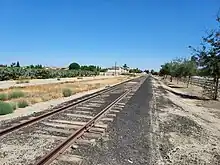
The rails from Tulare to Loma were removed in 1994.[2] A segment remains in place in Visalia, between "K" Ave (Ambler, now called Billy Goat Jct, also a connection with the SP/VE Visalia Branch) and Avenue 256 (Loma). Loma was the location of the last remaining rail shipper between Calwa and Corcoran, named Western Farm Service at the time. This shipper last received cars between 2007 and 2013, and the connection has since been taken out of service.[6]
Visalia to Calwa
The segment of line between Visalia and Cutler was not used by the TVRR and was removed by Dec-1994.
In Reedley, the right-of-way through town has been converted to a bike path.[7]
A short segment just northeast of Reedley is still in use by the SJVR, including the ATSF bridge over the Kings River and a spur to the facility at Lacjac.[8]
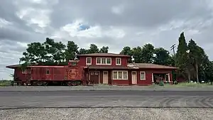
The last remaining depot is at Lone Star. This is a two-story type 2A depot which stands in its' original location. Built in 1913, the depot was closed for business in 1958 and is now privately owned.[9]
The stub end at Calwa is sometimes used to store ballast and Maintenance of way cars.
References
- 1 2 3 Bergman, John (2009). The Southern San Joaquin Valley (1 ed.). Jostens Printing and Publishing Company. pp. 57–61. ISBN 978-0-615-25105-9.
- 1 2 3 4 5 Bowen, D. 1995, March. San Joaquin Valley Railroad. CTC Board, Issue #197, 18-25.
- ↑ Santa Fe Valley Division, retrieved 2023-12-07
- 1 2 "Santa Fe Trail (Tulare) | California Trails | TrailLink". www.traillink.com. Retrieved 2023-12-26.
- ↑ "Parks | City of Tulare". www.tulare.ca.gov. Retrieved 2023-12-26.
- ↑ "Google Maps". Google Maps. Retrieved 2023-12-07.
- ↑ "Reedley Rail-Trail | California Trails | TrailLink". www.traillink.com. Retrieved 2024-01-15.
- ↑ "The Visalia District - Abandoned Rails". www.abandonedrails.com. Retrieved 2023-12-26.
- ↑ "ATSF Lone Star, CA Depot". atsf.railfan.net. Retrieved 2023-12-21.