| Site of Special Scientific Interest | |
 Wainlode Cliff | |
 Location within Gloucestershire | |
| Location | Gloucestershire |
|---|---|
| Grid reference | SO845257 |
| Coordinates | 51°55′48″N 2°13′34″W / 51.930046°N 2.226104°W |
| Interest | Geological |
| Area | 1.3 hectare |
| Notification | 1954 |
| Natural England website | |
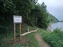
Wainlode Cliff (grid reference SO845257) is a 1.3 hectare geological Site of Special Scientific Interest in Gloucestershire, notified in 1954.[1][2] It overlooks Hasfield Ham.
Geology
This an historic locality which was first described in 1842 and shows a seven-metre section of Rhaetian age. The site mains the regional two-fold division of Westbury and Cotham Beds. The Insect Limestone, which is a productive source of insects, defines the base of the Lias.[1]
Fishing
Seasonal fishing is permitted on the riverbank beneath the cliff. Day tickets are available from the campsite shop, currently priced at £5 per day (2022).
Sources
References
External links
- English Nature (SSSI information)
 View from above Wainlode Cliff overlooking Hasfield Ham
This article is issued from Wikipedia. The text is licensed under Creative Commons - Attribution - Sharealike. Additional terms may apply for the media files.